Waterfalls near Greeneville, TN
24 named waterfalls within 30 miles of Greeneville, closest first. Distances are straight-line from the town center.
Visits with route details
Read the walking route, starting point and current access notes.
- Margarette FallsRoute and parking researchedGreene County, TN
- Pete's Branch FallsRoad and creek-crossing approach; total distance unconfirmedGreene County, TN
- Squibb Creek FallsResearched route and starting areaGreene County, TN
- Kelly FallsPartial guide: usual access road closed by flood damage; alternate drive to the falls not described12 ft (3.6 m) · Greene County, TN
- Hickey Fork FallsNational forest trail; steep path at the endMadison County, NC
- Dudley FallsSource-reviewed roadside view and parking10 ft (3 m) · Greene County, TN
- Ricker Branch FallsRoadside view across Forest Road 41 from a parking area15 ft (4.5 m) · Greene County, TN
- Trillium FallsPrivate property; roadside view onlyMadison County, NC
- Pine Ridge FallsNational forest trail route documented by visitor accounts; creek crossingUnicoi County, TN
- Birchfield Camp FallsPartial guide: total distance not stated; creek crossings without bridgesUnicoi County, TN
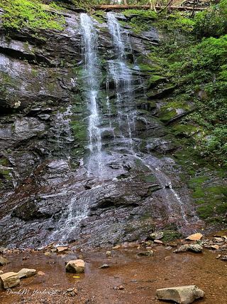 Sill Branch FallsGuide: short forest trail; keep left at the forkUnicoi County, TN
- Lower Higgins Creek FallsForest road route and parking documented; steep scramble to the baseUnicoi County, TN
- Spring Creek FallsRoadside pullout; short path to a bluff viewMadison County, NC
- Wolf Creek FallsPartial guide: unofficial approaches and long gravel roads; exact falls not confirmed by coordinates30 ft (9.1 m) · Cocke County, TN
- Martin Creek FallsPartial guide: parking at the gated road is not confirmed; unmarked side pathUnicoi County, TN
- Big Creek FallsRoadside waterfall with pullout and short bank pathYancey County, NC
- Little Fall Branch FallsPartial: short informal path; exact spot not publishedHaywood County, NC
All 24 waterfalls
- Margarette FallsRoute and parking researchedGreene County, TN9.7 miSE
- Camp Creek Falls148 ft (45 m) · Greene County, TN9.8 miSE
- Pete's Branch FallsRoad and creek-crossing approach; total distance unconfirmedGreene County, TN11 miSE
- Squibb Creek FallsResearched route and starting areaGreene County, TN12 miSE
- Kelly FallsPartial guide: usual access road closed by flood damage; alternate drive to the falls not described12 ft (3.6 m) · Greene County, TN13 miS
- Hickey Fork FallsNational forest trail; steep path at the endMadison County, NC13 miSE
- Dudley FallsSource-reviewed roadside view and parking10 ft (3 m) · Greene County, TN14 miS
- Ricker Branch FallsRoadside view across Forest Road 41 from a parking area15 ft (4.5 m) · Greene County, TN14 miS
- Longarm Branch FallsUnicoi County, TN16 miE
- Trillium FallsPrivate property; roadside view onlyMadison County, NC16 miSE
- Wilderness FallsUnicoi County, TN16 miE
- Hell Hollow FallsUnicoi County, TN17 miE
- Pine Ridge FallsNational forest trail route documented by visitor accounts; creek crossingUnicoi County, TN17 miE
- Josiah FallsUnicoi County, TN17 miE
- Birchfield Camp FallsPartial guide: total distance not stated; creek crossings without bridgesUnicoi County, TN17 miE
- Sill Branch FallsGuide: short forest trail; keep left at the forkUnicoi County, TN17 miE
- Lower Higgins Creek FallsForest road route and parking documented; steep scramble to the baseUnicoi County, TN17 miE
- Spring Creek FallsRoadside pullout; short path to a bluff viewMadison County, NC19 miS
- Needles FallsMadison County, NC20 miS
- Wolf Creek FallsPartial guide: unofficial approaches and long gravel roads; exact falls not confirmed by coordinates30 ft (9.1 m) · Cocke County, TN21 miS
- Cliff Dwellers Cascade15 ft (4.6 m) · Cocke County, TN24 miS
- Martin Creek FallsPartial guide: parking at the gated road is not confirmed; unmarked side pathUnicoi County, TN25 miE
- Big Creek FallsRoadside waterfall with pullout and short bank pathYancey County, NC27 miE
- Little Fall Branch FallsPartial: short informal path; exact spot not publishedHaywood County, NC29 miS