Pine Ridge Falls
Unicoi County, Tennessee
Your visit at a glance
- Waterfall height
- Not recorded
- Location
- Unicoi County, Tennessee
- Access status
- National forest trail route documented by visitor accounts; creek crossing
- The walk
- About half a mile, an estimate by Appalachian Treks; a creek crossing on the way
- Ground & access
- Mostly easy, flat trail. One creek crossing that can be tricky in high water. Poison ivy near the start in summer.
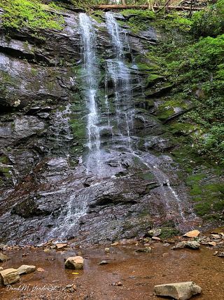
Pine Ridge Falls is a 25-foot waterfall on Devil's Fork in the Clarks Creek area of the Cherokee National Forest, Unicoi County. From the parking loop, a small brown sign marks the Longarm Branch Trail. After a short walk the trail crosses the creek; once across, it forks. Stay left; the falls are a short distance farther. A visitor account says the start of the trail is overgrown for about 50 yards, then becomes a relatively flat trail. The larger falls upstream (Josiah Falls) are reached only by climbing rocks and following a faint path; they are not part of this guide. Return the same way.
Plan your visit
Longarm Branch Trail parking loop on Clarks Creek Road, Longarm Branch Trail across the creek, then the left fork to Pine Ridge Falls
Appalachian Treks estimates the hike at about half a mile and does not say whether that is one way. No measured distance is published.
Mostly easy, flat trail. One creek crossing that can be tricky in high water. Poison ivy near the start in summer.
Where to start
From TN 107, turn onto Clarks Creek Road and drive 3.3 miles (the last 1.9 miles gravel) to a parking loop on the left, 0.2 miles past the Sill Branch Falls parking. The gravel road is narrow but not steep.
Timing & water
The creek crossing is harder in high water. Horseback riders use the road and trails.
Before you go
No fee is mentioned.
Visitor informationVisit sources
More waterfalls nearby
Within 40 straight-line miles. Road and trail distances will differ.
- Josiah FallsUnicoi County, TN0.4 miS
 Sill Branch FallsGuide: short forest trail; keep left at the forkUnicoi County, TN0.7 miNE
- Hell Hollow FallsUnicoi County, TN1.0 miN
- Wilderness FallsUnicoi County, TN1.0 miS
- Longarm Branch FallsUnicoi County, TN1.5 miSW
- Lower Higgins Creek FallsForest road route and parking documented; steep scramble to the baseUnicoi County, TN2.2 miS
- Birchfield Camp FallsPartial guide: total distance not stated; creek crossings without bridgesUnicoi County, TN2.2 miS
- Squibb Creek FallsResearched route and starting areaGreene County, TN5.9 miSW
- Pete's Branch FallsRoad and creek-crossing approach; total distance unconfirmedGreene County, TN6.8 miW