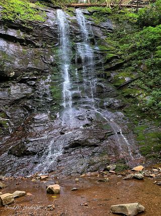
Lower Higgins Creek Falls
Unicoi County, Tennessee
Your visit at a glance
- Waterfall height
- Not recorded
- Location
- Unicoi County, Tennessee
- Access status
- Forest road route and parking documented; steep scramble to the base
- The walk
- About 0.6 mile to the trail view; Waterfall Hero lists the hike as 1.2 miles
- Ground & access
- Gated gravel road with a steady climb and creek crossings that are harder after heavy rain. The scramble down to the base is very steep and the rocks are slippery.
Lower Higgins Creek Falls is on Higgins Creek in the Unaka Ranger District of the Cherokee National Forest. From the turnaround at the end of the gravel spur road, walk up the gated road that continues along Higgins Creek. It climbs the whole way but is not too steep. In about 0.6 mile the falls is visible from the road. A steep scramble path leads down to the base. Return the same way.
Plan your visit
Turnaround at the end of the gravel spur off Lower Higgins Creek Road, then the gated road up Higgins Creek to the falls
Waterfall Hero says the waterfall is visible from the trail in about 0.6 mile and lists the hike length as 1.2 miles. A steep scramble path to the base adds a short, unmeasured distance.
Gated gravel road with a steady climb and creek crossings that are harder after heavy rain. The scramble down to the base is very steep and the rocks are slippery.
Where to start
From Erwin, take I-26 east about 6 miles to exit 43, turn left on US 19W south, then right to stay on US 19W. Drive 0.7 mile and turn right on Lower Higgins Creek Road for about 1.5 miles to its end. There is no parking there; a sign directs visitors 0.2 mile down a rough gravel road to a turnaround. Two wide spots about halfway down let you park and walk the last 0.1 mile.
Timing & water
No seasonal closure is mentioned.
Before you go
No fee is mentioned.
Visitor informationVisit sources
More waterfalls nearby
Within 40 straight-line miles. Road and trail distances will differ.
- Birchfield Camp FallsPartial guide: total distance not stated; creek crossings without bridgesUnicoi County, TN0.3 miW
- Wilderness FallsUnicoi County, TN1.3 miNW
- Longarm Branch FallsUnicoi County, TN1.4 miNW
- Josiah FallsUnicoi County, TN1.8 miN
- Pine Ridge FallsNational forest trail route documented by visitor accounts; creek crossingUnicoi County, TN2.2 miN
 Sill Branch FallsGuide: short forest trail; keep left at the forkUnicoi County, TN2.5 miN
- Hell Hollow FallsUnicoi County, TN3.1 miN
- Squibb Creek FallsResearched route and starting areaGreene County, TN5.6 miW
- Pete's Branch FallsRoad and creek-crossing approach; total distance unconfirmedGreene County, TN6.5 miW