Toquerville Falls
Washington County, Utah
Your visit at a glance
- Waterfall height
- 10 ft (3 m)
- Location
- Washington County, Utah
- Access status
- Rough dirt road to BLM falls; short walk without four-wheel drive
- The walk
- 0.2 miles from the turn at 5.6 miles if you park there, per St. George News
- Ground & access
- Short sandy road walk, then bare sandstone around the pools.
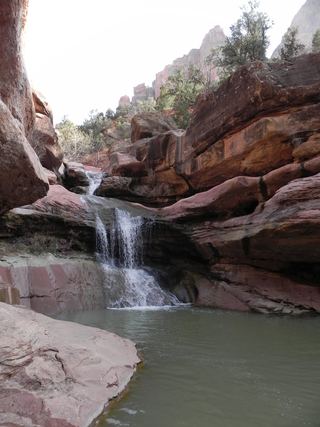
Toquerville Falls is a set of cascades and swimming pools on La Verkin Creek on Bureau of Land Management land northeast of Toquerville. From State Route 17 in Toquerville, turn east onto Spring Drive. The pavement ends after about 0.6 miles and a rough dirt road begins; stay right at the first fork, about 3.5 miles from town. The falls come into view from the road at about 5.3 miles. Turn right at the next turn, 5.6 miles from Toquerville. Without four-wheel drive, park there and walk the last 0.2 miles of sandy road. Return the same way.
Plan your visit
From UT-17 in Toquerville, east on Spring Drive (also called Spring Street), then the dirt road to the turn 5.6 miles from town, and the last 0.2 miles to the falls
St. George News gives 5.8 miles of road from Toquerville to the falls. The turn is 5.6 miles from town; without four-wheel drive, park there and walk the last 0.2 miles of sandy road.
Short sandy road walk, then bare sandstone around the pools.
Where to start
At the turn 5.6 miles from Toquerville, or at the falls with four-wheel drive. The dirt road is best suited to trucks and SUVs; sources differ on how rough it is, so a high-clearance vehicle is the safer choice.
Timing & water
Hike St. George says the falls run year round. The area can close for fire or other natural disasters. Do not drink the creek water without treating it.
Before you go
No permit is required, per Hike St. George. No fee is mentioned.
Visitor informationVisit sources
- St. George News: Toquerville Falls swimming hole
- St. George News: Toquerville Falls swimming hole
- St. George News: Toquerville Falls swimming hole
- St. George News: Toquerville Falls swimming hole
- St. George News: Toquerville Falls swimming hole
- Hike St. George: Toquerville Falls
- Hike St. George: Toquerville Falls
More waterfalls nearby
Within 40 straight-line miles. Road and trail distances will differ.
- Archangel FallsPartial guide: off-trail wilderness route; permit requiredWashington County, UT11 miE
- R3 - Keyhole Falls - Bolted Rappel Anchor: 10 ft.Washington County, UT11 miE
- R2 - Bolted Rappel Anchor: 6 ft.Washington County, UT11 miE
- Double FallsPartial guide: long off-trail creek route on a social trailWashington County, UT12 miE
- Barrier FallsPartial guide: long off-trail creek route on a social trailWashington County, UT13 miE
- Mystery Canyon FallsNational park trail and river route documented; flash flood risk131 ft (40 m) · Washington County, UT17 miE
- Menu FallsGuide: road walk from Big Bend to a viewing deckWashington County, UT17 miE
 Lower Pine Creek WaterfallPartial guide: unsigned social trail with boulder-hoppingWashington County, UT17 miE
 Lower Kanarra FallsPartial guide: permit hike documented; which drop this listing marks is not confirmedIron County, UT17 miN