Archangel Falls
Washington County, Utah
Your visit at a glance
- Waterfall height
- Not recorded
- Location
- Washington County, Utah
- Access status
- Partial guide: off-trail wilderness route; permit required
- The walk
- About 3.25 miles one way, per a photography guide
- Ground & access
- Off-trail canyon route: a steep descent and climb of about 400 feet, boulder scrambling, and wading in and out of the creek.
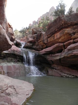
Archangel Falls is a series of stepped red cascades in the Left Fork of North Creek in Zion National Park, a few hundred yards below the Subway. Every hiker needs a wilderness permit for the Left Fork. From the Left Fork Trailhead on Kolob Terrace Road, a fairly flat half-mile walk leads to the rim, then a very steep trail drops about 400 feet into the canyon. Upstream there is no trail: this is an off-trail wilderness route with boulder scrambling and many creek crossings, and hikers get lost here every year, so carry a topographic map and a good route description. Pets are not allowed. Return the same way, including the steep climb out.
Plan your visit
Left Fork Trailhead on Kolob Terrace Road, steep trail down into the Left Fork of North Creek, then upstream on the off-trail Subway bottom-up route to Archangel Falls, a few hundred yards below the Subway
A photography guide places Archangel Falls 3.25 miles into the bottom-up hike. The park lists 9.0 miles round trip for the full bottom-up route to the Subway.
Off-trail canyon route: a steep descent and climb of about 400 feet, boulder scrambling, and wading in and out of the creek.
Where to start
Left Fork Trailhead, on the east side of Kolob Terrace Road 8.1 miles north of Virgin, with a large dirt lot, pit toilet and information kiosk.
Timing & water
Snow and ice in winter may require wet or dry suits, per the park. Do not enter the canyon when flash floods are possible.
Before you go
A wilderness permit is required year round for the Left Fork, per the park. Zion entrance fee: $35 per private vehicle. No permit fee is mentioned on the park pages read.
Visitor informationVisit sources
- Zion National Park: Left Fork (Subway) Bottom-Up
- Zion National Park: Left Fork (Subway) Bottom-Up
- Zion National Park: Left Fork (Subway) Bottom-Up
- Zion National Park: Left Fork (Subway) Bottom-Up
- Terra Galleria: Guide to hiking and photographing Zion's Subway
- Terra Galleria: Guide to hiking and photographing Zion's Subway
- Photographers Trail Notes: Archangel Falls
- Climb-Utah: The Subway
- Zion National Park: Fees and Passes
More waterfalls nearby
Within 40 straight-line miles. Road and trail distances will differ.
- R3 - Keyhole Falls - Bolted Rappel Anchor: 10 ft.Washington County, UT0.2 miNE
- R2 - Bolted Rappel Anchor: 6 ft.Washington County, UT0.4 miNE
- Double FallsPartial guide: long off-trail creek route on a social trailWashington County, UT2.6 miSE
- Barrier FallsPartial guide: long off-trail creek route on a social trailWashington County, UT2.6 miSE
- Mystery Canyon FallsNational park trail and river route documented; flash flood risk131 ft (40 m) · Washington County, UT6.1 miE
- Menu FallsGuide: road walk from Big Bend to a viewing deckWashington County, UT6.4 miE
 Lower Pine Creek WaterfallPartial guide: unsigned social trail with boulder-hoppingWashington County, UT8.2 miSE
- Toquerville FallsRough dirt road to BLM falls; short walk without four-wheel drive10 ft (3 m) · Washington County, UT11 miW
 Lower Kanarra FallsPartial guide: permit hike documented; which drop this listing marks is not confirmedIron County, UT17 miN