The Falls
Kane County, Utah
Your visit at a glance
- Waterfall height
- Not recorded
- Location
- Kane County, Utah
- Ground elevation
- About 6,226 ft above sea level
- Nearby mapped stream
- Kanab Creek
- Nearby mapped access
- No nearby parking or trailhead recorded
A nearby mapped parking area or trailhead may not connect to this waterfall. Confirm the route and public access before travelling.
The Falls is mapped in Kane County, Utah, 16.9 miles north of Kanab. This entry shows its location and nearby mapped places; a visitor route has not been confirmed.
About this location
Land & access
No named land ownership record was found at this location. This does not establish whether the land is public or private.
Water & terrain
Kanab Creek is mapped within 60 metres (about 200 feet) of the waterfall. Proximity alone does not confirm which stream feeds the falls.
Ground elevation is the land’s height above sea level, not the waterfall’s drop.
Sources for these details
Nearby streams and paths: OpenStreetMap. Land names: USGS PAD-US ownership records, with planning boundaries used only where ownership has no usable name. Ground elevation: USGS 3D Elevation Program.
Map records do not verify a walking route or current access conditions.
Before you make the trip
No nearby trailhead or parking area is recorded. Check the land manager’s visitor information for a permitted route.
Trail length, parking rules and current conditions have not been confirmed for this entry.
More waterfalls nearby
Within 40 straight-line miles. Road and trail distances will differ.
- Cascade FallsSource-reviewed route and parkingKane County, UT21 miNW
- Menu FallsGuide: road walk from Big Bend to a viewing deckWashington County, UT25 miW
- Mystery Canyon FallsNational park trail and river route documented; flash flood risk131 ft (40 m) · Washington County, UT25 miW
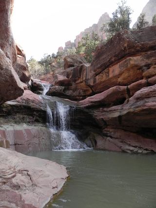 Lower Pine Creek WaterfallPartial guide: unsigned social trail with boulder-hoppingWashington County, UT26 miW
- Barrier FallsPartial guide: long off-trail creek route on a social trailWashington County, UT29 miW
- Double FallsPartial guide: long off-trail creek route on a social trailWashington County, UT29 miW
- R2 - Bolted Rappel Anchor: 6 ft.Washington County, UT31 miW
- R3 - Keyhole Falls - Bolted Rappel Anchor: 10 ft.Washington County, UT31 miW
- Archangel FallsPartial guide: off-trail wilderness route; permit requiredWashington County, UT31 miW