Wilson Falls
Tillamook County, Oregon
Your visit at a glance
- Waterfall height
- 200 ft (61 m)
- Location
- Tillamook County, Oregon
- Access status
- Established trail from Footbridge Trailhead; distance to the falls not given
- The walk
- Out-and-back trail walk; the distance from the Footbridge Trailhead to the falls is not given
- Ground & access
- Forest trail with ups and downs, log footbridges and an old road bed. A short walk along Highway 6 behind a fence and stone steps at the start. Trail shared with mountain bikers.
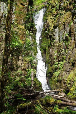
Wilson Falls is a long, narrow, multi-tiered seasonal waterfall, about 200 feet high, on an unnamed creek that splashes across the Wilson River Trail. From the Footbridge Trailhead, walk up the gravel path and south along Highway 6 behind a fence to stone steps that lead down to the footbridge over the Wilson River Narrows. Cross, go over a rocky knoll and an overflow channel to the Wilson River Trail, and turn toward Jones Creek. The trail crosses the small creek at the base of Wilson Falls high above the river. A sign marks the falls. The full height cannot be seen from the trail. Return the same way.
Plan your visit
Footbridge Trailhead on Highway 6, across the Wilson River footbridge, then east on the Wilson River Trail to the creek crossing at the base of Wilson Falls
Oregon Hikers gives 7.2 miles in and out for the whole Cedar Creek section between Jones Creek Trailhead and Footbridge Trailhead. Wilson Falls is partway along that section; no separate distance to the falls is given.
Forest trail with ups and downs, log footbridges and an old road bed. A short walk along Highway 6 behind a fence and stone steps at the start. Trail shared with mountain bikers.
Where to start
Footbridge Trailhead parking area on the right side of Highway 6, 32.0 miles after bearing left onto Highway 6 from Highway 26. Restrooms and picnic tables.
Timing & water
The creek is seasonal and the falls can be dry. Oregon Hikers says to check ahead for trail and highway closures in fall and winter, and to watch for black ice on Highway 6 in winter.
Before you go
No fee is mentioned.
Visitor informationVisit sources
More waterfalls nearby
Within 40 straight-line miles. Road and trail distances will differ.
- Bridge Creek FallsShort stone staircase from the highway to the baseTillamook County, OR0.8 miSW
- Kilchis FallsPartial guide: roadside falls on rough unmarked forest roads; no parking area describedTillamook County, OR4.5 miNW
- Fern Rock FallsRoadside turnout view documentedTillamook County, OR7.1 miE
- Stafford Falls98 ft (30 m) · Tillamook County, OR8.5 miNE
- University FallsState forest trail to the falls documentedTillamook County, OR8.9 miE
 Ki-a-Kuts FallsPartial: historical off-trail route documented; current logging-road permission and access unverifiedWashington County, OR11 miSE
- Haines FallsWashington County, OR14 miSE
- Nehalem FallsShort trail from a state forest campground to the riverside fallsTillamook County, OR14 miNW
- Lee FallsPartial guide: legal parking for the road walk not confirmedWashington County, OR16 miSE