Bridge Creek Falls
Tillamook County, Oregon
Your visit at a glance
- Waterfall height
- Not recorded
- Location
- Tillamook County, Oregon
- Access status
- Short stone staircase from the highway to the base
- The walk
- About 500 feet from the road to the base
- Ground & access
- Old stone steps and a short path. Crossing OR 6 on foot from the Footbridge Trailhead; watch for traffic. Brush can hide the lower tiers outside winter.
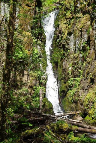
Bridge Creek Falls drops in three tiers on small Bridge Creek, just south of the Wilson River Highway (OR 6) near the Footbridge Trailhead in Tillamook County. A small wooden sign and an old stone staircase mark the start at the road. From the Footbridge Trailhead, head up the gravel trail from the parking area, cross the highway at the end of the crash barrier, and walk a few yards along the road to the stone staircase. Climb the stone steps and walkways beside the creek to the base of the falls. A small cistern sits at the base. Return the same way.
Plan your visit
OR 6 (Wilson River Highway) pullouts or the Footbridge Trailhead to the stone staircase up Bridge Creek
The Northwest Waterfall Survey puts the base of the falls about 500 feet from the road. It is a one-way figure.
Old stone steps and a short path. Crossing OR 6 on foot from the Footbridge Trailhead; watch for traffic. Brush can hide the lower tiers outside winter.
Where to start
Pullouts on either side of OR 6 just east of Bridge Creek, or the Footbridge Trailhead parking area a few hundred feet farther east, 32.0 miles along OR 6 from US 26. Restrooms and picnic tables at the trailhead.
Timing & water
Best in winter and early spring. By summer the creek can drop to a trickle or dry up. Watch for black ice on OR 6 in winter.
Before you go
No fee is mentioned.
Visitor informationVisit sources
- Northwest Waterfall Survey: Bridge Creek Falls
- Northwest Waterfall Survey: Bridge Creek Falls
- Northwest Waterfall Survey: Bridge Creek Falls
- Northwest Waterfall Survey: Bridge Creek Falls
- Oregon Hikers Field Guide: Footbridge Trailhead
- Oregon Hikers Field Guide: Footbridge Trailhead
- Oregon Hikers Field Guide: Footbridge Trailhead
More waterfalls nearby
Within 40 straight-line miles. Road and trail distances will differ.
- Wilson FallsEstablished trail from Footbridge Trailhead; distance to the falls not given200 ft (61 m) · Tillamook County, OR0.8 miNE
- Kilchis FallsPartial guide: roadside falls on rough unmarked forest roads; no parking area describedTillamook County, OR4.4 miNW
- Fern Rock FallsRoadside turnout view documentedTillamook County, OR7.8 miNE
- Stafford Falls98 ft (30 m) · Tillamook County, OR9.2 miNE
- University FallsState forest trail to the falls documentedTillamook County, OR9.6 miE
 Ki-a-Kuts FallsPartial: historical off-trail route documented; current logging-road permission and access unverifiedWashington County, OR12 miSE
- Haines FallsWashington County, OR14 miSE
- Nehalem FallsShort trail from a state forest campground to the riverside fallsTillamook County, OR15 miNW
- Lee FallsPartial guide: legal parking for the road walk not confirmedWashington County, OR16 miSE