Blumenthal Falls
Tillamook County, Oregon
Your visit at a glance
- Waterfall height
- Not recorded
- Location
- Tillamook County, Oregon
- Access status
- Trail and beach walk to the lower tier; upper user trails closed
- The walk
- About 1 mile from the parking lot to the falls
- Ground & access
- Forest trail, then sand beach. The sea can cover the whole beach at high tide; check a tide table first.
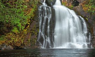
Blumenthal Falls is a small seasonal waterfall that tumbles in tiers to the sea at the north end of Short Sand Beach in Oswald West State Park. From the trailhead on US 101, follow the trail down along Short Sand Creek and follow signs to Short Sand Beach, then walk north along the beach. The lower tier can be seen from the north end of the beach, best at low tide. The steep user trails from the Cape Falcon Trail down to the upper falls are closed and posted with Danger signs; do not use them.
Plan your visit
Short Sand Beach (Cape Falcon) trailhead in Oswald West State Park to the north end of Short Sand Beach
The Northwest Waterfall Survey gives approximately one mile from the parking lot to the falls, by the trail and a beach walk. It is a one-way figure.
Forest trail, then sand beach. The sea can cover the whole beach at high tide; check a tide table first.
Where to start
Trailhead pullout on the west side of US 101 in Oswald West State Park, about 5.75 miles north of Nehalem and 4.25 miles south of Arch Cape, with overflow parking across the highway. The lot is closed from 10 p.m. to 6 a.m.
Timing & water
Flow is low and the creek almost dries up in summer; visit in the wet season and at low tide.
Before you go
Oregon Hikers lists a $10 day-use parking fee at this trailhead.
Visitor informationVisit sources
- Oregon Hikers Field Guide: Blumenthal Falls
- Oregon Hikers Field Guide: Blumenthal Falls
- Oregon Hikers Field Guide: Blumenthal Falls
- Northwest Waterfall Survey: Blumenthal Falls
- Northwest Waterfall Survey: Blumenthal Falls
- Northwest Waterfall Survey: Blumenthal Falls
- Oregon Hikers Field Guide: Cape Falcon Hike
- Oregon Hikers Field Guide: Cape Falcon Hike
More waterfalls nearby
Within 40 straight-line miles. Road and trail distances will differ.
 Hug Point FallsBeach walk documented; passable at low tide onlyClatsop County, OR4.6 miN
- Nehalem FallsShort trail from a state forest campground to the riverside fallsTillamook County, OR10.0 miE
- Kilchis FallsPartial guide: roadside falls on rough unmarked forest roads; no parking area describedTillamook County, OR19 miSE
 Youngs River FallsVerified parking and downhill approachClatsop County, OR23 miNE
- Fishhawk FallsResearched walking routeClatsop County, OR23 miNE
- Bridge Creek FallsShort stone staircase from the highway to the baseTillamook County, OR23 miSE
- Wilson FallsEstablished trail from Footbridge Trailhead; distance to the falls not given200 ft (61 m) · Tillamook County, OR23 miSE
- Fern Rock FallsRoadside turnout view documentedTillamook County, OR28 miSE
- Stafford Falls98 ft (30 m) · Tillamook County, OR29 miE