Superior Falls
Gogebic County, Michigan
Your visit at a glance
- Waterfall height
- Not recorded
- Location
- Gogebic County, Michigan
- Access status
- Researched walking route
- The walk
- 0.5–1 mile; trip basis unspecified
- Ground & access
- Gravel or dirt, rocky and uneven, with rough sections.
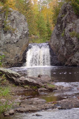
Signed viewing areas overlook the Montreal River falls near Lake Superior. The tourism directions explicitly cross into Michigan.
Plan your visit
From the gravel-road parking area off Highway 122, follow the signs for the upper and lower viewing areas.
Wisconsin tourism lists “Distance to Falls 0.5-1 mile” without identifying one-way or return. No round-trip total is inferred.
Gravel or dirt, rocky and uneven, with rough sections.
Where to start
From Hurley, drive about 12.5 miles west on US 2, turn right on Highway 122 north for approximately 4.2 miles across the Michigan border, then continue another 0.5 mile to the gravel road on the left and parking area.
Timing & water
Seasonal access or current closures not verified.
Before you go
Wisconsin tourism lists free admission; no reservation information is stated.
Visitor informationVisit sources
More waterfalls nearby
Within 40 straight-line miles. Road and trail distances will differ.
- Superior FallsPower company site open to the public; short walkGogebic County, MI0.2 miS
- Saxon Falls RoadIron County, WI2.5 miSE
- Lower Potato River FallsCounty park stair trail to a deck facing the lower fallsIron County, WI8.9 miSW
- Upper Potato River FallsCounty park trail to an observation deckIron County, WI8.9 miSW
- Foster FallsCounty forest road to a parking area near the fallsIron County, WI9.9 miS
- Interstate FallsPublished short trail to a viewing platformGogebic County, MI12 miSE
 Wren FallsRough forest road to a trail parking area and an overlook above the fallsIron County, WI12 miS
- Upson FallsTown park with a short trail to the fallsIron County, WI13 miS
- Algonquin FallsGogebic County, MI17 miE