Upson Falls
Iron County, Wisconsin
Your visit at a glance
- Waterfall height
- Not recorded
- Location
- Iron County, Wisconsin
- Access status
- Town park with a short trail to the falls
- The walk
- Short trail; no distance is published
- Ground & access
- Short trail with a rocky incline.
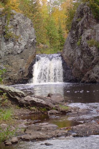
Upson Falls drops about 20 feet on the Potato River just north of Upson. Turn north off Highway 77 at the Upson Town Park sign, then left at the end of the street. After crossing the river, turn left into Upson Town Park. A fairly short trail with a rocky incline leads to the falls. A visitor account describes walking upstream from the park shelter past smaller falls and rapids to the larger falls.
Plan your visit
Upson Town Park off Highway 77 in Upson, then a short trail to the falls
Travel Wisconsin calls it a fairly short trail. No distance is given.
Short trail with a rocky incline.
Where to start
Upson Town Park. A specific parking lot is not described.
Timing & water
No season is stated.
Before you go
No fee is mentioned.
Visitor informationVisit sources
More waterfalls nearby
Within 40 straight-line miles. Road and trail distances will differ.
- Foster FallsCounty forest road to a parking area near the fallsIron County, WI4.3 miNW
 Wren FallsRough forest road to a trail parking area and an overlook above the fallsIron County, WI4.9 miNW
- Upper Potato River FallsCounty park trail to an observation deckIron County, WI8.4 miNW
- Lower Potato River FallsCounty park stair trail to a deck facing the lower fallsIron County, WI8.5 miNW
- CascadesPartial guide: state park trail; exact feature not confirmedAshland County, WI11 miW
- Brownstone FallsState park loop trail with overlooks of the fallsAshland County, WI11 miW
 Copper FallsPavilion parking and waterfall loop researchedAshland County, WI11 miW
- Saxon Falls RoadIron County, WI12 miN
- Red Granite FallsState park gravel trail to rapids on the Bad RiverAshland County, WI12 miW