Red Fork Falls
Unicoi County, Tennessee
Your visit at a glance
- Waterfall height
- Not recorded
- Location
- Unicoi County, Tennessee
- Access status
- Partial guide: unofficial path and a dangerous scramble to the base; land manager not confirmed
- The walk
- About half a mile, per visitor accounts
- Ground & access
- Short unofficial path with two creek crossings that can be wet in high flow, then a very steep, slippery scramble to the base. Not suitable for children or dogs, per visitor accounts.
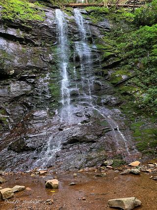
Red Fork Falls is a 60-foot waterfall, the main drop in a series of falls on Red Fork on the side of Unaka Mountain near Unicoi. From TN 107 (Limestone Cove Road), turn onto Red Fork Road (Unaka Mountain Road) and drive about 1.2 miles to a small pull-off on the right marked by a red dot on a tree. The path drops to a creek crossing, bears right across a second creek, and follows the creek a short way to the top of the falls. Visitor accounts say getting to the base means climbing down a near-vertical, slick slope beside the falls using rocks and roots, and that people have been badly hurt and killed here. Stay off the rocks at the top of the falls. The path is not an official trail and the land manager is not confirmed by an official source, so this is a partial guide.
Plan your visit
Pull-off on Red Fork Road (Unaka Mountain Road) marked by a red dot on a tree, unofficial path across two creeks to the top of the falls, then a very steep scramble beside the falls to the base
Visitor accounts describe a short half-mile hike, and one gives about one mile round trip. The last part is a near-vertical descent beside the falls.
Short unofficial path with two creek crossings that can be wet in high flow, then a very steep, slippery scramble to the base. Not suitable for children or dogs, per visitor accounts.
Where to start
Small pull-off on the right side of Red Fork Road (Unaka Mountain Road) about 1.2 miles up from TN 107, marked by a red dot on a tree, per visitor accounts. The road is narrow with no guardrails.
Timing & water
Creek crossings are harder after rain. Ice makes the rocks especially dangerous in winter.
Before you go
No fee is mentioned.
Visitor informationVisit sources
More waterfalls nearby
Within 40 straight-line miles. Road and trail distances will differ.
- Martin Creek FallsPartial guide: parking at the gated road is not confirmed; unmarked side pathUnicoi County, TN7.5 miW
- Big Creek FallsRoadside waterfall with pullout and short bank pathYancey County, NC10.0 miSW
- Fall Creek FallsMitchell County, NC10 miSE
- Coon Den FallsGuide: steep forest trail; park at the gravel area past the trailheadCarter County, TN11 miNE
- Laurel FallsForest Service route and trailheads documentedCarter County, TN11 miNE
- Dennis Cove WaterfallNational forest trail route documented; three wading fordsCarter County, TN11 miNE
 Sill Branch FallsGuide: short forest trail; keep left at the forkUnicoi County, TN15 miW
- Hell Hollow FallsUnicoi County, TN15 miW
- Josiah FallsUnicoi County, TN15 miW