McClure Falls
Newton County, Arkansas
Your visit at a glance
- Waterfall height
- Not recorded
- Location
- Newton County, Arkansas
- Access status
- Current road and parking access unconfirmed
- The walk
- 6.4 miles for the reported multi-waterfall outing
- Ground & access
- Remote paths and off-trail bluff detours. Descents have loose shale and slippery steep slopes. Returning from below the falls requires climbing back out.
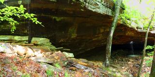
Two firsthand accounts reach McClure Falls from the Kapark area by way of Ken Smith Falls. Lost in the Ozarks describes a steep descent below the bluffs; its 2022 trip included both waterfalls. A maintained, signed final approach is not established.
Plan your visit
Kapark approach past Ken Smith Falls
The 2022 GPS total includes Ken Smith Falls, McClure Falls and bluff detours. It is not a separately measured direct round trip to McClure. Parking farther back on the rough road adds walking.
Remote paths and off-trail bluff detours. Descents have loose shale and slippery steep slopes. Returning from below the falls requires climbing back out.
Where to start
Lost in the Ozarks reports spaces at the road junction near Kapark Cemetery and parking at the cemetery. Its approach uses Cave Mountain Road, FR 1410 and FR 1410B; the last section requires high clearance and four-wheel drive in its account. Current road status and parking authorization have not been confirmed.
Timing & water
Check current access and conditions before travel; the reviewed source does not establish a reliable visiting season.
Before you go
Fees, permits and reservation requirements for this visit have not been confirmed; check with the land manager.
Visitor informationVisit sources
More waterfalls nearby
Within 40 straight-line miles. Road and trail distances will differ.
- Ken Smith FallsUpper-drop identity documented; approach and parking incompleteNewton County, AR0.1 miS
- Bowers Hollow FallsResearched visit notes56 ft (17.1 m) · Newton County, AR0.8 miNW
- Adkins Canyon FallsFirsthand route and parking documented; difficult unmarked bushwhack and creek crossing42 ft (12.8 m) · Newton County, AR1.5 miS
- Leaning Log FallsPartial: one visitor account, no trail, and no single-fall distance27 ft (8.2 m) · Newton County, AR1.6 miS
- Stahle FallsRoadside parking authorization unconfirmed63 ft (19.2 m) · Newton County, AR1.9 miNE
- Hadlock CascadePartial: stated limitations remain27 ft (8.2 m) · Newton County, AR2.0 miNE
- Woods Boys FallsSource-reviewed route and parking33 ft (10.1 m) · Newton County, AR2.0 miNE
- Magnolia FallsSource-reviewed route and parking26 ft (7.9 m) · Newton County, AR2.1 miNE
 Glory HoleSource-reviewed route and roadside parking limitation31 ft (9.5 m) · Newton County, AR2.4 miSE