Magnolia Falls
Newton County, Arkansas
Your visit at a glance
- Waterfall height
- 26 ft (7.9 m)
- Location
- Newton County, Arkansas
- Access status
- Source-reviewed route and parking
- The walk
- About 1.0 mile one way from the roadside parking (about 2.0 miles round trip)
- Ground & access
- Easy old road for most of the way, then a short, steeper creek-side path with a few fallen trees. Wet ground and shallow water can cover parts of the road.
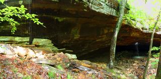
Park at the widened roadside access on NC 9050 and follow the old road northwest. About a quarter mile in, take the well-defined trail at the branch (one account describes the old road bending left past a stream crossing). Pass a stone wall, and at a small creek about 0.9 mile from the start leave the trail and follow the creek downstream a couple hundred yards to Magnolia Falls, which has a grotto and pool at its base. The route is inside the Upper Buffalo Wilderness. Return the way you came.
Plan your visit
Old road from the NC 9050 wilderness access, then a short creek-side path to Magnolia Falls
Distances are from a 2025 firsthand mileage log; the 3.6 mile total in that log is for all four Boen Gulf falls and is not the Magnolia distance.
Easy old road for most of the way, then a short, steeper creek-side path with a few fallen trees. Wet ground and shallow water can cover parts of the road.
Where to start
Widened gravel shoulder on NC 9050, about 0.4 mile west of Highway 21 (2015 coordinates 35.86289, -93.38516; 2025 coordinates 35.862801, -93.385118). A Wilderness Access sign marks the old road. NC 9050 appears as FR 1462 or CR 6 on older maps.
Timing & water
Best after rain; the 2015 visit was in drought with low flow.
Before you go
No fee is listed in the reviewed accounts.
Visitor informationVisit sources
More waterfalls nearby
Within 40 straight-line miles. Road and trail distances will differ.
- Woods Boys FallsSource-reviewed route and parking33 ft (10.1 m) · Newton County, AR0.0 miW
- Hadlock CascadePartial: stated limitations remain27 ft (8.2 m) · Newton County, AR0.1 miW
- Stahle FallsRoadside parking authorization unconfirmed63 ft (19.2 m) · Newton County, AR0.2 miW
- Paradise FallsBushwhack approach and parking not currently verified32 ft (9.8 m) · Newton County, AR1.1 miN
- McClure FallsCurrent road and parking access unconfirmedNewton County, AR2.1 miSW
- Ken Smith FallsUpper-drop identity documented; approach and parking incompleteNewton County, AR2.2 miSW
- Bowers Hollow FallsResearched visit notes56 ft (17.1 m) · Newton County, AR2.2 miW
- Beagle Point FallsApproach or parking partly unconfirmed76 ft (23.2 m) · Newton County, AR3.0 miW
 Glory HoleSource-reviewed route and roadside parking limitation31 ft (9.5 m) · Newton County, AR3.0 miS