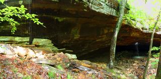
Ken Smith Falls
Newton County, Arkansas
Your visit at a glance
- Waterfall height
- Not recorded
- Location
- Newton County, Arkansas
- Access status
- Upper-drop identity documented; approach and parking incomplete
- The walk
- Distance to this drop unverified
- Ground & access
- Remote wilderness; lower-falls descents described as steep, slick and loose shale.
Firsthand visits describe a well-worn path from the Kapark trailhead to Ken Smith Falls and McClure Falls. The approach to the upper drop and the current parking are incomplete.
Plan your visit
A November 2017 firsthand report walked from Kapark trailhead to Ken Smith Falls and nearby McClure Falls. The opened sources do not supply a sufficiently detailed junction-by-junction approach to this upper drop.
Lost in the Ozarks measured 6.4 miles for a February 2022 trip including lower Ken Smith and McClure Falls. That combined distance is not assigned to this upper drop.
Remote wilderness; lower-falls descents described as steep, slick and loose shale.
Where to start
Kapark trailhead is named by the 2017 visitor. Present vehicle access and exact authorized parking not verified.
Timing & water
2017 visitor found only a trickle after prolonged dry weather.
Before you go
Unknown.
Visitor informationVisit sources
More waterfalls nearby
Within 40 straight-line miles. Road and trail distances will differ.
- McClure FallsCurrent road and parking access unconfirmedNewton County, AR0.1 miN
- Bowers Hollow FallsResearched visit notes56 ft (17.1 m) · Newton County, AR0.9 miNW
- Adkins Canyon FallsFirsthand route and parking documented; difficult unmarked bushwhack and creek crossing42 ft (12.8 m) · Newton County, AR1.4 miS
- Leaning Log FallsPartial: one visitor account, no trail, and no single-fall distance27 ft (8.2 m) · Newton County, AR1.5 miS
- Stahle FallsRoadside parking authorization unconfirmed63 ft (19.2 m) · Newton County, AR2.0 miNE
- Hadlock CascadePartial: stated limitations remain27 ft (8.2 m) · Newton County, AR2.1 miNE
- Woods Boys FallsSource-reviewed route and parking33 ft (10.1 m) · Newton County, AR2.1 miNE
- Magnolia FallsSource-reviewed route and parking26 ft (7.9 m) · Newton County, AR2.2 miNE
 Glory HoleSource-reviewed route and roadside parking limitation31 ft (9.5 m) · Newton County, AR2.4 miSE