Haw Creek Falls
Johnson County, Arkansas
Your visit at a glance
- Waterfall height
- 6 ft (1.8 m)
- Location
- Johnson County, Arkansas
- The walk
- About 100 yards each way
- Ground & access
- Short walk on the recreation-site trail, which the Forest Service describes as accessible. The rocks at the falls are uneven and slippery when wet. The entrance crosses a low-water bridge that can flood.
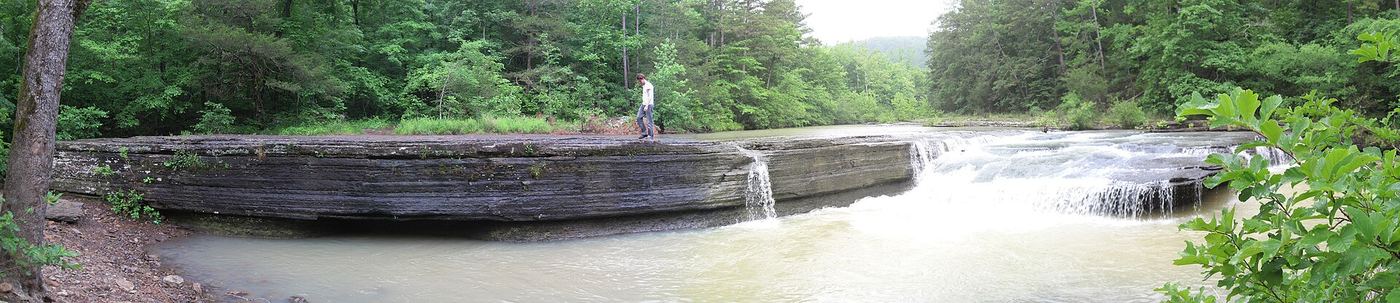
Haw Creek Falls is a small cascading waterfall inside the Forest Service's Haw Creek Falls recreation site. The Forest Service lists an accessible trail to the falls. A firsthand account says to drive counterclockwise around the campground loop and park near the two restrooms, with the falls on the right about 100 yards from the road.
Plan your visit
From the parking area beside the two restrooms in Haw Creek Falls Campground, walk a short distance to the falls.
Approximate distance from a firsthand visitor account (visit 2013, page updated 2020). A 2024 newspaper report also describes the falls as steps from parking. Not a measured accessible-route length.
Short walk on the recreation-site trail, which the Forest Service describes as accessible. The rocks at the falls are uneven and slippery when wet. The entrance crosses a low-water bridge that can flood.
Where to start
Park inside Haw Creek Falls Campground near the two restrooms, reached by driving counterclockwise around the campground loop. While the Fort Douglas trailhead is closed for bridge work, the Forest Service also directs Ozark Highlands Trail hikers to park at Haw Creek Falls Campground. Do not drive across the low-water bridge when water is over it.
Timing & water
Listed as open year-round. The Highway 123 bridge over Big Piney Creek is closed for repairs from August 31 to about December 3, 2026, with a signed detour by Highways 164 and 7. Check the detour before driving.
Before you go
The Forest Service 2026 recreation schedule lists Haw Creek Falls day use and its 9-site campground as free.
Visitor informationVisit sources
- Forest Service: Haw Creek Falls
- Arkansas and Oklahoma Hiker: Haw Creek Falls (visit 2013, updated 2020)
- Forest Service alert, September 28, 2026
- Forest Service alert: Highway 123 bridge closure dates
- Harrison Daily Times, June 8, 2024, page B4
- Forest Service: 2026 recreation schedule and fees, page 3, Haw Creek Falls day use row (listed Free)
More waterfalls nearby
Within 40 straight-line miles. Road and trail distances will differ.
- Pack Rat FallsResearched walking route24 ft (7.3 m) · Johnson County, AR0.4 miS
- Pam's GrottoSource-reviewed route and parking37 ft (11.3 m) · Johnson County, AR0.4 miN
- Car Wash FallsRoadside location; parking and road status unverified21 ft (6.4 m) · Johnson County, AR1.9 miN
- V-Slot FallsPartial: one visitor account, land ownership and parking legality not confirmed10 ft (3.1 m) · Johnson County, AR4.0 miE
- Swamp FallsPartial: user-submitted route; land ownership and legal parking not confirmed19 ft (5.8 m) · Johnson County, AR4.0 miE
- Sidewinder FallsInformal approach documented; individual waterfall distance unknown21 ft (6.4 m) · Johnson County, AR4.0 miE
- Hobo Falls EastPublished parking and approach verified; creek crossing and canyon spur23 ft (7 m) · Johnson County, AR4.4 miW
- Hobo Falls WestSource-reviewed route and parking27 ft (8.2 m) · Johnson County, AR4.5 miW
- Highway 123 FallsResearched walking route47 ft (14.3 m) · Johnson County, AR4.5 miSW