Chocolate Falls
Skamania County, Washington
Your visit at a glance
- Waterfall height
- Not recorded
- Location
- Skamania County, Washington
- Access status
- National volcanic monument trail with lava-field crossings; falls often dry by midsummer
- The walk
- 5.7 miles round trip with 1,150 feet of gain, per Oregon Hikers
- Ground & access
- Forest trail to June Lake, then a steep climb and several traverses over rough lava fields on the Loowit Trail.
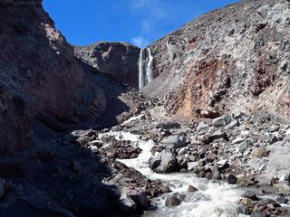
Chocolate Falls is a 40-foot waterfall on the south side of Mount St. Helens, named because its water can carry so much volcanic ash that it looks like chocolate milk. From the June Lake Trailhead, follow the June Lake Trail up through forest along June Creek and across a footbridge. Just before June Lake, the trail continues ahead and climbs steeply about 0.3 mile to the Loowit Trail. Turn west (left) on the Loowit Trail and continue just over a mile, crossing several lava fields, to the falls. Return the same way. Oregon Hikers notes the lava-field crossings may be hard for children.
Plan your visit
June Lake Trailhead off Forest Road 83 on the south side of Mount St. Helens, up the June Lake Trail and on to the Loowit Trail, then west on the Loowit Trail to the falls
Oregon Hikers says to continue about 0.3 mile up from June Lake to the Loowit Trail, then just over a mile west to Chocolate Falls, and gives the trip as 5.7 miles out and back with 1,150 feet of elevation gain.
Forest trail to June Lake, then a steep climb and several traverses over rough lava fields on the Loowit Trail.
Where to start
June Lake Trailhead, a paved day-use lot at the top of a short paved spur off Forest Road 83, 7.1 miles from Forest Road 90. Overnight hikers must park elsewhere.
Timing & water
Oregon Hikers lists June to November for hiking and says Chocolate Falls usually dries up by midsummer. In winter the road to the trailhead is closed and access is from Marble Mountain Sno-Park.
Before you go
No fee is mentioned; WTA and Oregon Hikers list no parking pass or fee.
Visitor informationVisit sources
More waterfalls nearby
Within 40 straight-line miles. Road and trail distances will differ.
- Lava Canyon FallsMonument trail; steep cliff-edge section past a closed bridge132 ft (40.2 m) · Skamania County, WA4.4 miE
 Loowit FallsMonument trail to the falls overlook186 ft (56.7 m) · Skamania County, WA4.6 miN
- Step FallsMonument trail; the falls are seen from the Loowit Trail near the Loowit Creek ford115 ft (35 m) · Skamania County, WA4.6 miN
- Lower Step Falls98 ft (30 m) · Skamania County, WA4.8 miN
- Middle Loowit FallsSkamania County, WA4.9 miN
- Upper Sheep Canyon FallsPartial: last section is an unsigned, possibly abandoned trail98 ft (30 m) · Cowlitz County, WA5.1 miNW
- Sheep Canyon Falls89 ft (27 m) · Cowlitz County, WA5.1 miNW
- Swift Creek FallsSkamania County, WA5.2 miS
- Lower Loowit FallsNational monument trails from Windy Ridge; falls seen from the Loowit Trail ford36 ft (11 m) · Skamania County, WA5.2 miN