Whychus Creek Falls
Deschutes County, Oregon
Your visit at a glance
- Waterfall height
- Not recorded
- Location
- Deschutes County, Oregon
- Access status
- Canyon trail hike to a small creek waterfall
- The walk
- 3.5 miles round trip
- Ground & access
- Dirt trail with a climb to a bench and switchbacks below a cliff. Summers are often hot, with possible wildfire smoke.
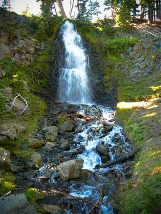
This listing sits at the point Oregon Hikers gives for Logjam Falls, a small waterfall where logs have jammed between large boulders on Whychus Creek, in the canyon below the Whychus Creek Overlook. From the Whychus Creek Trailhead, the trail winds down through manzanita and bitterbrush under ponderosa pines, passes the sign for the Wild and Scenic River section, and drops to creek level at rock overhangs. It then rises to a higher bench at the edge of a burned area, drops over the rim, switchbacks below a colorful cliff face, and heads up the creek to the falls. The best view is from a large boulder just downstream of the falls. Return the same way.
Plan your visit
Whychus Creek Trailhead on Three Creek Road south of Sisters, Whychus Creek Trail upstream to Logjam Falls
Oregon Hikers gives 3.5 miles round trip, out and back, from the Whychus Creek Trailhead to Logjam Falls.
Dirt trail with a climb to a bench and switchbacks below a cliff. Summers are often hot, with possible wildfire smoke.
Where to start
Whychus Creek Trailhead: from the center of Sisters, drive south on Elm Street, which becomes Three Creek Road, 4.3 miles and pull off to the right at the hiker sign. A first trailhead 140 yards earlier, at a green gate, has been closed.
Timing & water
All year except after heavy snowfall. Spring and fall are best.
Before you go
No fee is mentioned.
Visitor informationVisit sources
- Oregon Hikers Field Guide: Logjam Falls
- Oregon Hikers Field Guide: Logjam Falls Hike
- Oregon Hikers Field Guide: Logjam Falls Hike
- Oregon Hikers Field Guide: Logjam Falls Hike
- Oregon Hikers Field Guide: Logjam Falls Hike
- Oregon Hikers Field Guide: Logjam Falls Hike
- Oregon Hikers Field Guide: Logjam Falls Hike
More waterfalls nearby
Within 40 straight-line miles. Road and trail distances will differ.
- Chush FallsTrailhead parking and overlook approach documented; current conditions unverified67 ft (20.4 m) · Deschutes County, OR7.0 miSW
- The CascadesPartial guide: informal paths past Chush Falls; current trailhead location not confirmedDeschutes County, OR7.2 miSW
- Columnar Canyon Falls125 ft (38.1 m) · Deschutes County, OR7.3 miSW
- Upper Chush FallsPartial guide: final approach is an unmaintained user trail with no measured distance223 ft (68 m) · Deschutes County, OR7.4 miSW
- Howlaak Falls70 ft (21.3 m) · Deschutes County, OR7.6 miSW
- Phoenix Falls110 ft (33.5 m) · Deschutes County, OR8.1 miSW
- Upper Tumalo FallsForest trail to a partly obscured viewpoint documentedDeschutes County, OR12 miS
 Obsidian FallsLong wilderness trail; limited-entry permit requiredLane County, OR12 miW
- Double FallsForest trail past Tumalo Falls to cliff-top viewpointsDeschutes County, OR13 miS