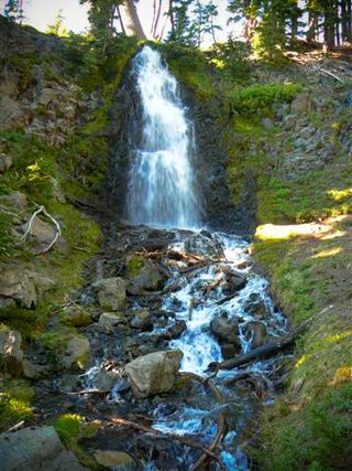
Chush Falls
Deschutes County, Oregon
Your visit at a glance
- Waterfall height
- 67 ft (20.4 m)
- Location
- Deschutes County, Oregon
- Access status
- Trailhead parking and overlook approach documented; current conditions unverified
- The walk
- A little over 2 miles each way to the overlook; allow over 4 miles return
- Ground & access
- Old roadbed, forest trail, creek crossing on logs, deadfall and uphill sections; cliff-edge viewpoint.
Oregon Hikers describes a route through the Pole Creek burn to a partial view of Chush Falls.
Plan your visit
From Chush Falls Trailhead follow the old road, keeping right at the split. At the old trailhead take the signed trail uphill left, then continue to the bluff view of Chush Falls. Return the same way.
SoCalHiker’s 2019 report describes the trail-end overlook a little beyond two miles from parking. Its five-mile total includes a separate scramble to the base. This guide stops at the overlook.
Old roadbed, forest trail, creek crossing on logs, deadfall and uphill sections; cliff-edge viewpoint.
Where to start
Use Chush Falls trailhead parking at the end of the Forest Road 1514-600 approach. Oregon Hikers directs drivers from Sisters along Three Creek Road for 7.3 miles, then right on FR 1514; stay right at FR 1516, turn left before the Whychus Creek bridge and continue about 0.9 mile on the rougher road. SoCalHiker’s firsthand report confirms vehicles parked at this signed trailhead.
Timing & water
Source suggests mid-spring to mid-fall; current road and trail conditions unverified.
Before you go
A self-issued wilderness permit is listed by Oregon Hikers. SoCalHiker reports a recreation pass for parking; confirm current pass requirements with the forest. Overnight trips require the applicable Central Cascades Wilderness Permit.
Visitor informationVisit sources
More waterfalls nearby
Within 40 straight-line miles. Road and trail distances will differ.
- The CascadesPartial guide: informal paths past Chush Falls; current trailhead location not confirmedDeschutes County, OR0.2 miSW
- Columnar Canyon Falls125 ft (38.1 m) · Deschutes County, OR0.4 miW
- Upper Chush FallsPartial guide: final approach is an unmaintained user trail with no measured distance223 ft (68 m) · Deschutes County, OR0.5 miS
- Howlaak Falls70 ft (21.3 m) · Deschutes County, OR0.5 miSW
- Phoenix Falls110 ft (33.5 m) · Deschutes County, OR1.1 miSW
 Obsidian FallsLong wilderness trail; limited-entry permit requiredLane County, OR6.8 miW
- Whychus Creek FallsCanyon trail hike to a small creek waterfallDeschutes County, OR7.0 miNE
- Fall Creek FallsEstablished wilderness trail; permit required in summerDeschutes County, OR8.1 miS
- Upper Tumalo FallsForest trail to a partly obscured viewpoint documentedDeschutes County, OR8.3 miSE