The Cascades
Deschutes County, Oregon
Your visit at a glance
- Waterfall height
- Not recorded
- Location
- Deschutes County, Oregon
- Access status
- Partial guide: informal paths past Chush Falls; current trailhead location not confirmed
- The walk
- About a quarter mile, or 10 minutes, past Chush Falls on informal paths; the trailhead has been moved since older directions were written
- Ground & access
- Burned forest on the approach. Past Chush Falls, informal, unmaintained paths on steep canyon slopes.
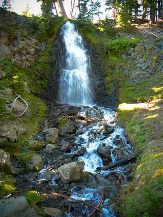
The Cascades is a nearly sheer 26-foot drop on Whychus Creek just above its confluence with Park Creek, upstream of Chush Falls, just inside the Three Sisters Wilderness south of Sisters. The Chush Falls trail ends at a canyon-rim viewpoint of Chush Falls. Beyond it there is no maintained trail; informal paths continue upstream, and the next falls at the Park Creek confluence is about 10 minutes on. Stay within earshot of the creek, because many footpaths branch in this area. After the Pole Creek Fire, the Forest Service closed part of the old access road and moved the trailhead, so older driving directions to the end of road 1514-600 are out of date. The current trailhead location is not described in detail by these sources.
Plan your visit
Chush Falls trail along Whychus Creek in the Three Sisters Wilderness, then informal paths upstream from Chush Falls to The Cascades
Northwest Waterfall Survey places The Cascades about a quarter mile past Chush Falls. The Nugget Newspaper says the next falls is about 10 minutes past Chush Falls and that the rerouted trail makes the round trip to Chush Falls almost five miles. No current figure from the trailhead to The Cascades is given.
Burned forest on the approach. Past Chush Falls, informal, unmaintained paths on steep canyon slopes.
Where to start
The Chush Falls trailhead is off Forest Road 16 and FR 1514 south of Sisters. Since the Pole Creek Fire, road 600 is blocked partway and the trail follows the former 680 Road; the Forest Service says the new and old trailheads are about 1.3 miles apart. Exact current parking is not confirmed.
Timing & water
High-elevation wilderness area; snowmelt flow peaks in late spring. No seasonal closure is stated.
Before you go
No fee is mentioned.
Visitor informationVisit sources
- Northwest Waterfall Survey: The Cascades
- Northwest Waterfall Survey: The Cascades
- The Nugget Newspaper: Post-fire Chush Falls is a completely different hike
- The Nugget Newspaper: Post-fire Chush Falls is a completely different hike
- The Nugget Newspaper: Post-fire Chush Falls is a completely different hike
- USDA Forest Service: Chush Falls Trailhead Relocation
More waterfalls nearby
Within 40 straight-line miles. Road and trail distances will differ.
- Chush FallsTrailhead parking and overlook approach documented; current conditions unverified67 ft (20.4 m) · Deschutes County, OR0.2 miNE
- Upper Chush FallsPartial guide: final approach is an unmaintained user trail with no measured distance223 ft (68 m) · Deschutes County, OR0.3 miS
- Columnar Canyon Falls125 ft (38.1 m) · Deschutes County, OR0.3 miNW
- Howlaak Falls70 ft (21.3 m) · Deschutes County, OR0.4 miW
- Phoenix Falls110 ft (33.5 m) · Deschutes County, OR0.9 miSW
 Obsidian FallsLong wilderness trail; limited-entry permit requiredLane County, OR6.7 miW
- Whychus Creek FallsCanyon trail hike to a small creek waterfallDeschutes County, OR7.2 miNE
- Fall Creek FallsEstablished wilderness trail; permit required in summerDeschutes County, OR7.9 miS
- Upper Tumalo FallsForest trail to a partly obscured viewpoint documentedDeschutes County, OR8.3 miSE