Waterfalls near Staunton, VA
6 named waterfalls within 30 miles of Staunton, closest first. Distances are straight-line from the town center.
Visits with route details
Read the walking route, starting point and current access notes.
- St. Mary's FallsNational forest wilderness trail with five river crossingsAugusta County, VA
- Upper Shamokin FallsShort loop on Wintergreen trails, stated open to the publicAugusta County, VA
- White Rock FallsTrail from a Blue Ridge Parkway overlook; unsigned trailheadNelson County, VA
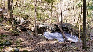 Jones Run FallsNational park trail from a Skyline Drive parking area; entrance fee42 ft (12.8 m) · Albemarle County, VA
- Lower Doyles River FallsNational park trail from a Skyline Drive parking area; entrance fee62 ft (19 m) · Albemarle County, VA
- Upper Doyles River FallsGuide: park trail down to the upper falls28 ft (8.5 m) · Albemarle County, VA
All 6 waterfalls
- St. Mary's FallsNational forest wilderness trail with five river crossingsAugusta County, VA15 miS
- Upper Shamokin FallsShort loop on Wintergreen trails, stated open to the publicAugusta County, VA17 miSE
- White Rock FallsTrail from a Blue Ridge Parkway overlook; unsigned trailheadNelson County, VA17 miS
- Jones Run FallsNational park trail from a Skyline Drive parking area; entrance fee42 ft (12.8 m) · Albemarle County, VA21 miE
- Lower Doyles River FallsNational park trail from a Skyline Drive parking area; entrance fee62 ft (19 m) · Albemarle County, VA22 miE
- Upper Doyles River FallsGuide: park trail down to the upper falls28 ft (8.5 m) · Albemarle County, VA22 miE