Upper Doyles River Falls
Albemarle County, Virginia
Your visit at a glance
- Waterfall height
- 28 ft (8.5 m)
- Location
- Albemarle County, Virginia
- Access status
- Guide: park trail down to the upper falls
- The walk
- 3.1 miles out and back to the upper falls (Hiking Project)
- Ground & access
- Steady descent on the way in and a climb back out; Hiking Project lists about 960 feet of climb. One stream crossing.
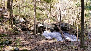
Upper Doyles River Falls is the first of two waterfalls on the Doyles River Trail in Shenandoah National Park. From the parking area near mile 81 on Skyline Drive, take the Doyles River Trail downhill and cross the Appalachian Trail. Stay right where a side trail climbs to the locked Doyles River Cabin, and continue about two-thirds of a mile to Browns Gap Road. Cross the road; the trail crosses the Doyles River after a few hundred yards. Follow the trail as it bends right in a wide hairpin to a low point with a sign, where the whole falls comes into view. Trail posts mark the upper and lower falls. Return uphill the same way.
Plan your visit
Doyles River Parking Area (Skyline Drive mile 81.1), blue-blazed Doyles River Trail across the Appalachian Trail and Browns Gap Road to the signed upper falls
Hiking Project gives 3.1 miles out and back to the upper falls. The National Park Service gives 3.3 miles round trip for the hike to both the upper and lower falls.
Steady descent on the way in and a climb back out; Hiking Project lists about 960 feet of climb. One stream crossing.
Where to start
Doyles River Parking Area on Skyline Drive at mile 81.1.
Timing & water
The park lists the Doyles River hike as open year-round.
Before you go
Shenandoah National Park entrance fee required: $30 per private vehicle, valid for seven days. The park does not accept cash. No booking is needed for this hike.
Visitor informationVisit sources
More waterfalls nearby
Within 40 straight-line miles. Road and trail distances will differ.
- Lower Doyles River FallsNational park trail from a Skyline Drive parking area; entrance fee62 ft (19 m) · Albemarle County, VA0.2 miSW
 Jones Run FallsNational park trail from a Skyline Drive parking area; entrance fee42 ft (12.8 m) · Albemarle County, VA1.1 miSW
- Cedar FallsRockingham County, VA13 miNE
- South River FallsOfficial park trail to an observation point; entrance fee89 ft (27 m) · Greene County, VA14 miNE
- Dry Run FallsFire road walk to a view of the falls; exact viewpoint not described; off-trail to the streamRockingham County, VA14 miNE
- Big Creek Falls151 ft (46 m) · Page County, VA19 miNE
- Upper Big Creek Falls33 ft (10 m) · Page County, VA19 miNE
- Naked Creek FallsPartial guide: off-trail creek descent; exact drop not confirmedPage County, VA21 miNE
- Big Rock FallsPublished hike route and national park parking documentedMadison County, VA23 miNE