Pumpkinseed Creek Falls
King County, Washington
Your visit at a glance
- Waterfall height
- Not recorded
- Location
- King County, Washington
- Access status
- Steep national forest trail; falls about a mile from the trailhead
- The walk
- About a mile from the trailhead, per WTA
- Ground & access
- Steep, rocky trail; rocks underfoot can be a tripping hazard. About 1,000 feet of climbing in the first mile.
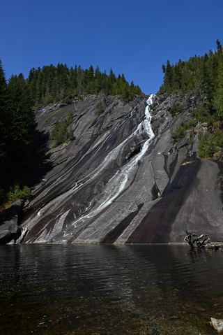
Pumpkinseed Falls slides about 25 feet down a granite face into a small pool on Pumpkinseed Creek, fed by Pumpkinseed Lake, beside the Dingford Creek Trail in the Mount Baker-Snoqualmie National Forest. From the Dingford Creek trailhead, take the trail marked for Dingford Creek and climb steeply up the hillside past moss-covered boulders, with Dingford Creek to your right. About a mile in, the trail passes the falls. Return the same way. This is a separate falls from Dingford Creek Falls at the trailhead bridge.
Plan your visit
Dingford Creek Trailhead at the end of the Dingford road off the Middle Fork Snoqualmie Road, Dingford Creek Trail #1005 about a mile up to the falls
WTA says the trail passes Pumpkinseed Falls about a mile in. Hiking Project says the trail gains about 1,000 feet in that first mile. No round-trip figure is given for the falls alone.
Steep, rocky trail; rocks underfoot can be a tripping hazard. About 1,000 feet of climbing in the first mile.
Where to start
Dingford Creek Trailhead at a gate about six miles up a heavily potholed gravel road. From I-90 exit 34, follow 468th Street to the Middle Fork Snoqualmie Road, drive 12 miles to the Middle Fork trailhead, continue past it and turn right on the gravel road just after the large concrete bridge, marked for Dingford and Dutch Miller Gap.
Timing & water
No season limits are stated.
Before you go
America the Beautiful Pass or Northwest Forest Pass. Passes and a privy are at the trailhead.
Visitor informationVisit sources
More waterfalls nearby
Within 40 straight-line miles. Road and trail distances will differ.
- Dingford Creek FallsPartial: short viewpoint near the trailhead from one visitor report; rough access roadKing County, WA0.7 miSW
- Lower Tin Cup Joe FallsKing County, WA2.3 miW
- Tin Cup Joe Falls463 ft (141.1 m) · King County, WA2.4 miW
- Nine Hour FallsKing County, WA3.2 miW
- Nellie Falls150 ft (45.7 m) · King County, WA4.2 miE
- Big Creek FallsSource-reviewed route and parking236 ft (72 m) · King County, WA4.4 miN
 Otter FallsRoute documented; landslide-damaged creek crossing reported by WTA.1,200 ft (365.8 m) · King County, WA4.9 miN
- Florence FallsIdentity context documented; waterfall route and parking unresolved141 ft (43 m) · King County, WA6.0 miNE
- Snowshoe FallsNational forest wilderness trail with an unbridged creek ford; partial view of the falls150 ft (45.7 m) · King County, WA6.1 miS