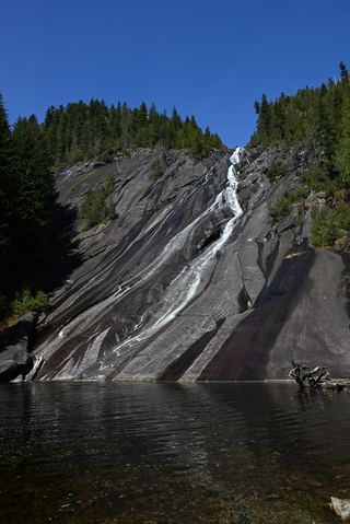
Big Creek Falls
King County, Washington
Your visit at a glance
- Waterfall height
- 236 ft (72 m)
- Location
- King County, Washington
- Access status
- Source-reviewed route and parking
- The walk
- 9.2 miles round trip
- Ground & access
- Rocky former logging road and multiple drainage crossings. WTA describes a winter 2025 landslide roughly a quarter mile past Marten Creek, before the Otter Falls turnoff, leaving a deep channel and potentially unstable boulders on the shared approach to Big Creek Falls.
WTA describes crossing the Taylor River bridge, taking the right fork at the Quartz Creek junction, crossing Marten Creek and continuing past the Otter Falls turnoff to Big Creek Falls at the concrete bridge. The shared approach includes the landslide-damaged crossing described by WTA; check its condition before committing to the route.
Plan your visit
Snoqualmie Lake Trail along Taylor River to Big Creek Falls
Only the stated source distance is supported; mapped proximity is not a walking distance.
Rocky former logging road and multiple drainage crossings. WTA describes a winter 2025 landslide roughly a quarter mile past Marten Creek, before the Otter Falls turnoff, leaving a deep channel and potentially unstable boulders on the shared approach to Big Creek Falls.
Where to start
Use Snoqualmie Lake Trailhead at the end of Middle Fork Road, beyond the Garfield Ledges parking area. WTA identifies a small parking area and a toilet.
Timing & water
High water can make drainage crossings difficult. Check recent specific crossing reports and ranger conditions before travel.
Before you go
WTA lists Northwest Forest Pass or America the Beautiful Pass.
Visitor informationVisit sources
More waterfalls nearby
Within 40 straight-line miles. Road and trail distances will differ.
 Otter FallsRoute documented; landslide-damaged creek crossing reported by WTA.1,200 ft (365.8 m) · King County, WA0.7 miNW
- Florence FallsIdentity context documented; waterfall route and parking unresolved141 ft (43 m) · King County, WA3.4 miE
- Pumpkinseed Creek FallsSteep national forest trail; falls about a mile from the trailheadKing County, WA4.4 miS
- Dingford Creek FallsPartial: short viewpoint near the trailhead from one visitor report; rough access roadKing County, WA4.7 miS
- Nine Hour FallsKing County, WA4.8 miSW
- Lower Tin Cup Joe FallsKing County, WA5.1 miS
- Tin Cup Joe Falls463 ft (141.1 m) · King County, WA5.2 miS
- Kanim Falls280 ft (85.3 m) · King County, WA5.5 miN
- Borderline Falls20 ft (6.1 m) · King County, WA5.5 miN