Scotsman Creek Falls
Jackson County, North Carolina
Your visit at a glance
- Waterfall height
- Not recorded
- Location
- Jackson County, North Carolina
- Access status
- Partial: no real trail; very steep unofficial path from the road
- The walk
- About 0.1 miles (Waterfall Hero hike length), very steep
- Ground & access
- Very steep descent with large fallen trees to climb over. Rocks at the falls are very slippery.
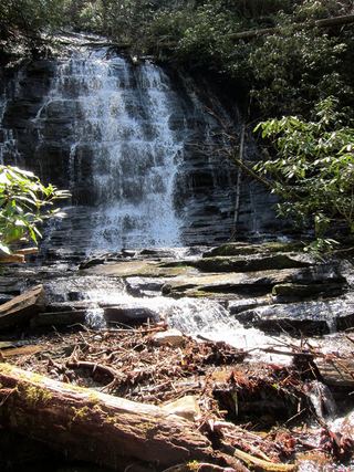
In the right-hand curve where you park, look for a faint path heading down to the creek. Waterfall Hero found flagging tape. It is barely a trail and very steep; follow the sound of the falls. The 50-foot falls split into two free-falling streams around a small island, with a large rocky area at the base. Return the same way.
Plan your visit
Roadside on Bull Pen Road (FS 1178) at a right-hand curve, then a faint, very steep path down to Scotsman Creek
Waterfall Hero lists the hike length as 0.1 miles. The difficulty is the steep descent, not the distance.
Very steep descent with large fallen trees to climb over. Rocks at the falls are very slippery.
Where to start
Along the side of Bull Pen Road in a right-hand curve about 4.3 miles from NC 107, a few hundred feet past gated Forest Road 4564. There is little pull-off space, so get completely off the road. Trailhead coordinates: 35.01731, -83.11242.
Timing & water
No closure is stated by the sources. The route description dates from 2020.
Before you go
Ellicott Rock Wilderness, Nantahala Ranger District, Nantahala National Forest. No fee is stated by the sources.
Visitor informationVisit sources
More waterfalls nearby
Within 40 straight-line miles. Road and trail distances will differ.
- Lower Scotsman Creek FallsPartial guide: no trail below Scotsman Falls; wading and bushwhacking from 2005 directionsJackson County, NC0.1 miS
- Upper Scotsman Creek FallsNational forest; roadside parking and a short off-trail descentJackson County, NC0.1 miN
- Pothole FallsRoadside bridge view; scramble to the baseMacon County, NC0.8 miW
- Fowler Creek FallsPartial: wilderness trail then an extremely steep bushwhackJackson County, NC0.9 miS
- Pleasant Grove Church FallsJackson County, NC1.6 miNE
- Cane Creek FallsPartial guide: no trail, steep bushwhack from a gated forest roadMacon County, NC1.9 miNW
 Spoonauger FallsSource-reviewed route and parkingOconee County, SC2.9 miS
- Stick FallsNational forest; short bushwhack with a cliffMacon County, NC2.9 miW
- Lower Stick FallsPartial: short but steep bushwhack near cliffs; no trailMacon County, NC3.0 miW