Lower Catawaba Falls
McDowell County, North Carolina
Your visit at a glance
- Waterfall height
- Not recorded
- Location
- McDowell County, North Carolina
- Access status
- National forest trail; view from the trail only
- The walk
- About 0.9 miles each way
- Ground & access
- Mostly easy trail with a footbridge and one easy rock hop. No access to the base.
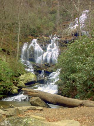
From I-40 Exit 73 in Old Fort take Catawba River Road 3.1 miles to its end at the large Forest Service parking area. Start on Catawba Falls River Trail to the right of the restrooms. After an easy quarter mile cross the 103 foot footbridge over the Catawba River by the old hydropower ruins. Continue about half a mile to Clover Patch Branch, an easy rock hop, then a little less than 0.1 miles on River Trail to the overlook of Lower Catawba Falls with the old Old Fort Dam at its top. The former side path to the base is gone after Tropical Storm Helene. Catawba Falls is about a quarter mile farther.
Plan your visit
Catawba Falls trailhead at the end of Catawba River Road, Catawba Falls River Trail to the Lower Catawba Falls overlook
NC Waterfalls gives a hike distance of 0.9 miles to the view from the trail. Waterfall Hero lists a hike length of 1.8 miles, which is about 0.9 miles each way.
Mostly easy trail with a footbridge and one easy rock hop. No access to the base.
Where to start
Large Forest Service parking lot at the end of Catawba River Road, 3.1 miles from I-40 Exit 73. Restrooms at the trailhead. Do not park elsewhere on the road.
Timing & water
The Forest Service says the whole Catawba Falls loop trail is open, but the upper viewing platform and Wildflower Trail remain closed after Hurricane Helene. Stay on River Trail. Check the Forest Service page before visiting.
Before you go
No fee is mentioned on the Forest Service page.
Visitor informationVisit sources
More waterfalls nearby
Within 40 straight-line miles. Road and trail distances will differ.
 Catawba FallsLoop open; upper platform and Wildflower Trail closedMcDowell County, NC0.2 miSW
 Upper Catawba FallsPartial: loop trail open; the Forest Service lists the upper viewing platform as closedMcDowell County, NC0.4 miSW
- Davids FallsNational forest trail; river crossings on the spurMcDowell County, NC0.9 miSW
- Graybeard FallsPrivate conservation land open to hikers; blazed trailBuncombe County, NC5.3 miNW
- Slick FallsMcDowell County, NC6.3 miN
- Standing Rock FallsMcDowell County, NC6.8 miSE
- Hickory Branch FallsMcDowell County, NC6.8 miNE
- Licklog Branch FallsMcDowell County, NC7.6 miN
- Broad River FallsBuncombe County, NC8.5 miS