Courthouse Falls
Transylvania County, North Carolina
Your visit at a glance
- Waterfall height
- 33 ft (10 m)
- Location
- Transylvania County, North Carolina
- Access status
- Approach road closed due to storm damage; no open parking-to-falls route verified.
- The walk
- Current usable approach distance unknown
- Ground & access
- Wet railroad grade, narrow trail, slippery log bridges and wooden steps.
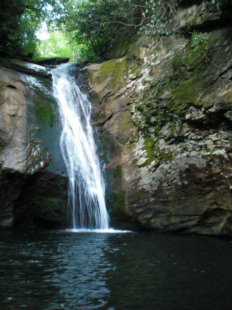
Courthouse Falls lies at the end of a narrow spur off Summey Cove Trail. The road closure prevents treating the older drive-up approach as available.
Plan your visit
The published route uses Summey Cove Trail from the FS 140 pull-off, then the distinct Courthouse Falls spur on the left. FS 140 is currently closed; no alternative access is verified.
The older USFS handout lists a 0.3-mile trail but does not clearly separate the spur from the full parking approach. No return distance is inferred.
Wet railroad grade, narrow trail, slippery log bridges and wooden steps.
Where to start
The older handout identifies a small pull-off on FS 140 beyond a creek crossing. It is not presented as reachable while that road is closed.
Timing & water
The current USFS Helene recovery page reviewed October 27, 2026 lists Courthouse Creek Road (FS 140) closed due to storm damage.
Before you go
Fees and booking requirements unknown.
Visitor informationVisit sources
More waterfalls nearby
Within 40 straight-line miles. Road and trail distances will differ.
- Cody FallsPartial guide: Courthouse Creek Road is closed for storm damage and foot access on it is not confirmedTransylvania County, NC0.1 miSW
- Lower Chestnut FallsPartial guide: access road closed for storm damage; bushwhack and creek walkTransylvania County, NC0.5 miNE
- Summey Cove FallsPartial: FS 140 closed for storm damage; view mostly blocked by treesTransylvania County, NC0.6 miS
- Chestnut FallsPartial guide: FR 140 closed for storm damage; long road walk and faint pathTransylvania County, NC0.6 miNE
- Kiesee FallsPartial guide: access road closed for storm damage; bushwhack with an exposed rock faceTransylvania County, NC0.9 miNE
- Upper Kiesee FallsPartial guide: the access road is closed and the path may have changed since loggingTransylvania County, NC0.9 miNE
- Upper Courthouse FallsPartial guide: Courthouse Creek Road is closed to vehicles, so the walk is about 4 miles each wayTransylvania County, NC0.9 miN
- Upper Beetree Fork FallsShort road walk and bank scramble from a national forest pull-offTransylvania County, NC1.4 miS
- Beetree Fork FallsDocumented road walk and bank scramble on national forest land33 ft (10 m) · Transylvania County, NC1.4 miS