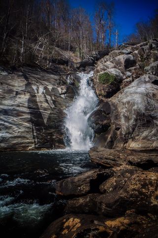
Bearcamp Creek Falls
Transylvania County, North Carolina
Your visit at a glance
- Waterfall height
- Not recorded
- Location
- Transylvania County, North Carolina
- Access status
- Partial guide: route source is from 2006 and the match to this waterfall is probable
- The walk
- About 5.8 miles each way, added up from a 2006 account
- Ground & access
- Long, hilly Foothills Trail with footbridges. Remote; plan for a full day.
A 2006 account describes Bearcamp Falls (also called Hilliard Falls), about 60 feet, on a short marked spur of the Foothills Trail between the Thompson and Horsepasture rivers. From the Foothills Trail parking inside the Bad Creek gate in South Carolina, hike 0.7 mile to the Foothills Trail at the Whitewater River, turn right, follow the white blazes 2.7 miles to the Thompson River footbridge, then 2.2 miles more to the marked spur, which leads less than a quarter mile to the base. The account does not give coordinates, so the match to this waterfall is probable, not confirmed.
Plan your visit
Bad Creek (SC) Foothills Trail access, Foothills Trail east past the Thompson River to the Bearcamp Falls spur
Added up from the 2006 account's segments: 0.7 mile to the Foothills Trail, 2.7 miles to the Thompson River bridge, 2.2 miles to the spur, and under 0.25 mile on the spur. The author estimated 5 to 6 miles one way.
Long, hilly Foothills Trail with footbridges. Remote; plan for a full day.
Where to start
Foothills Trail parking inside the Bad Creek property gate (South Carolina). The 2006 account says the gate opens automatically and to read the posted signs. Current gate hours and rules unverified.
Timing & water
Current trail and gate status unverified; the only route source is from 2006.
Before you go
No fee found in the archived account. Check posted rules at the Bad Creek gate.
Visitor informationVisit sources
More waterfalls nearby
Within 40 straight-line miles. Road and trail distances will differ.
- Mill Creek FallsOconee County, SC0.6 miSE
- Rudis FallsTransylvania County, NC1.3 miNW
- Hilliard FallsLong backcountry trail hike; about 12 miles returnTransylvania County, NC1.4 miNW
- Standing Up Rock FallsTransylvania County, NC1.8 miN
- Rooster Tail FallsTransylvania County, NC2.0 miNW
- Hen Tail FallsTransylvania County, NC2.0 miN
- Big FallsPartial guide: unofficial trail, dangerous ford and scramble; parking and land permission details unconfirmed197 ft (60 m) · Transylvania County, NC2.1 miW
- Standing Stone FallsTransylvania County, NC2.1 miW
 Windy FallsPartial guide: unofficial route to the top of a dangerous falls; trail name not in the current park trail list197 ft (60 m) · Transylvania County, NC2.2 miN