Waterfalls near Woodlake, CA
10 named waterfalls within 30 miles of Woodlake, closest first. Distances are straight-line from the town center.
Visits with route details
Read the walking route, starting point and current access notes.
- Marble FallsOfficial trail; NPS distance figures differTulare County, CA
- Panther Creek FallsPartial guide: viewing spot for the falls not described154 ft (47 m) · Tulare County, CA
- Ella FallsPublished park trail loop documented; private lake road not for public useTulare County, CA
- Viola FallsPartial guide: route from non-NPS guides; Sunset Trail partly closed for October 2026 prescribed fireTulare County, CA
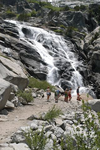 Tokopah FallsResearched visit notesTulare County, CA
- Tufa FallsPartial guide: falls are above the trail and screened by foliage; a clear viewpoint is not confirmedTulare County, CA
All 10 waterfalls
- Marble FallsOfficial trail; NPS distance figures differTulare County, CA20 miNE
- Panther Creek FallsPartial guide: viewing spot for the falls not described154 ft (47 m) · Tulare County, CA23 miNE
- Ella FallsPublished park trail loop documented; private lake road not for public useTulare County, CA23 miN
- Viola FallsPartial guide: route from non-NPS guides; Sunset Trail partly closed for October 2026 prescribed fireTulare County, CA23 miN
- Lower Buck Creek FallsTulare County, CA26 miE
- Tokopah FallsResearched visit notesTulare County, CA26 miNE
- Tufa FallsPartial guide: falls are above the trail and screened by foliage; a clear viewpoint is not confirmedTulare County, CA28 miE
- Lower Cliff Creek FallsTulare County, CA29 miE
- Upper Cliff Creek FallsTulare County, CA29 miE
- Upper Buck Creek FallsTulare County, CA29 miNE