Sioux Falls
St. Louis County, Minnesota
Your visit at a glance
- Waterfall height
- Not recorded
- Location
- St. Louis County, Minnesota
- Access status
- Canoe route documented; restricted BWCA permit quota
- The walk
- River canoe trip of just under 5 miles each way, plus a 10-rod portage beside the falls
- Ground & access
- River paddling, then a short portage. The landing at the base of the falls is a rock ledge. Stay well clear of the lip of the falls.
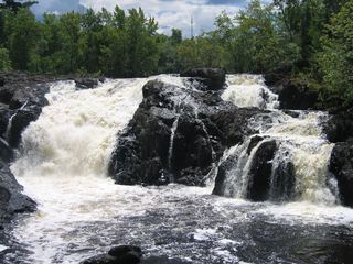
Sioux Falls is reached by canoe. From the Entry Point 9 parking lot on the Echo Trail, carry 8 rods to the Little Indian Sioux River and paddle downstream just under five miles. Land on the left side, well back from the top of the falls, and take the short downhill portage beside the waterfall. Return upstream the same way, or continue on a longer trip.
Plan your visit
Canoe down the Little Indian Sioux River from BWCA Entry Point 9 on the Echo Trail to the Sioux Falls portage
BWCAwild gives just under five river miles from the Entry Point 9 landing to Sioux Falls, and lists the falls portage at 10 rods (about 165 feet). This is a paddling distance, not a walk.
River paddling, then a short portage. The landing at the base of the falls is a rock ledge. Stay well clear of the lip of the falls.
Where to start
Entry Point 9 parking lot, on the right side of the Echo Trail about 39 miles west of Ely. The 8-rod carry to the river crosses the Echo Trail.
Timing & water
Open-water paddling season only. BWCAwild last visited September 2020. Current conditions unverified.
Before you go
A Boundary Waters permit for Entry Point 9 is required. BWCAwild reports a quota of one group every other day, the most restricted in the BWCA. Permit fees not verified.
Visitor informationVisit sources
More waterfalls nearby
Within 40 straight-line miles. Road and trail distances will differ.
- Devils CascadePartial guide: exact hiking trailhead parking is unconfirmedSt. Louis County, MN7.1 miN
- Loon FallsSt. Louis County, MN10 miNW
- Dry FallsForest Service trail and published out-and-back distanceSt. Louis County, MN19 miSE
- High FallsOfficial short trail and rest area documentedSt. Louis County, MN20 miNW
- Lower Basswood FallsLake County, MN23 miE
- Pipestone FallsCanoe route documented; parking and permit details unverifiedLake County, MN23 miE
 Kawishiwi FallsShort trail from a free lot; rocks and rootsLake County, MN24 miSE
- Newton FallsLake County, MN25 miE