Dry Falls
St. Louis County, Minnesota
Your visit at a glance
- Waterfall height
- Not recorded
- Location
- St. Louis County, Minnesota
- Access status
- Forest Service trail and published out-and-back distance
- The walk
- About 2 miles return
- Ground & access
- Rugged and steep where the trail climbs about 60 feet up the ridge near Dry Falls, per the Forest Service. Rock, roots and wet spots.
Drive the Echo Trail 2.6 miles north from County Road 88 to the Bass Lake Trail parking lot on the north side of the road, about 6 miles north of Ely. Follow the Bass Lake Trail to Dry Falls, where the outflow of Dry Lake drops toward Bass Lake. Junctions have numbered maps. Return the same way, or continue on one of the longer loops.
Plan your visit
Bass Lake Trail parking on the Echo Trail (County Road 116) to Dry Falls
Quetico Superior Foundation gives about two miles round trip for the out-and-back to Dry Falls. Longer loops around Bass Lake and Dry Lake are separate.
Rugged and steep where the trail climbs about 60 feet up the ridge near Dry Falls, per the Forest Service. Rock, roots and wet spots.
Where to start
Bass Lake Trail parking lot on the north side of the Echo Trail, 2.6 miles north of County Road 88. Vault toilet near the lot.
Timing & water
Year-round per the visitor account. No cell coverage, per the Forest Service.
Before you go
No fee is listed on the Forest Service trail page read.
Visitor informationVisit sources
More waterfalls nearby
Within 40 straight-line miles. Road and trail distances will differ.
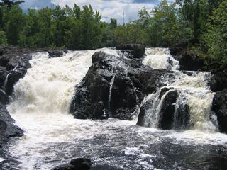 Kawishiwi FallsShort trail from a free lot; rocks and rootsLake County, MN5.0 miE
- Newton FallsLake County, MN6.6 miE
- Pipestone FallsCanoe route documented; parking and permit details unverifiedLake County, MN6.9 miNE
- Lower Basswood FallsLake County, MN13 miNE
- Sioux FallsCanoe route documented; restricted BWCA permit quotaSt. Louis County, MN19 miNW
- Devils CascadePartial guide: exact hiking trailhead parking is unconfirmedSt. Louis County, MN25 miNW
- Loon FallsSt. Louis County, MN29 miNW
- Eddy FallsLake County, MN36 miE
- High FallsOfficial short trail and rest area documentedSt. Louis County, MN39 miNW