Loon Falls
St. Louis County, Minnesota
Your visit at a glance
- Waterfall height
- Not recorded
- Location
- St. Louis County, Minnesota
- Ground elevation
- About 1,151 ft above sea level
- Land
- Miscellaneous
- Nearby mapped access
- No nearby parking or trailhead recorded
A nearby mapped parking area or trailhead may not connect to this waterfall. Confirm the route and public access before travelling.
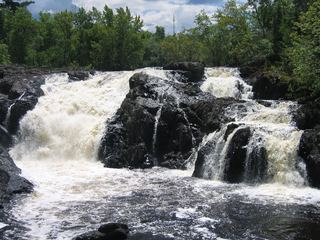
Loon Falls is mapped in St. Louis County, Minnesota, 31.3 miles northwest of Ely. This entry shows its location and nearby mapped places; a visitor route has not been confirmed.
About this location
Land & access
The land ownership record at this location lists Miscellaneous. The listed manager is state natural resources department. The land record lists public access. Check the manager’s current visitor information for permitted routes and closures.
Nearby named trails
- Loon Falls Portage
These paths are mapped within 250 metres (about 820 feet) of the waterfall. A connection to a viewpoint has not been verified.
Sources for these details
Nearby streams and paths: OpenStreetMap. Land names: USGS PAD-US ownership records, with planning boundaries used only where ownership has no usable name. Ground elevation: USGS 3D Elevation Program.
Map records do not verify a walking route or current access conditions.
Before you make the trip
No nearby trailhead or parking area is recorded. Check the land manager’s visitor information for a permitted route.
Trail length, parking rules and current conditions have not been confirmed for this entry.
More waterfalls nearby
Within 40 straight-line miles. Road and trail distances will differ.
- Devils CascadePartial guide: exact hiking trailhead parking is unconfirmedSt. Louis County, MN4.1 miSE
- Sioux FallsCanoe route documented; restricted BWCA permit quotaSt. Louis County, MN10 miSE
- High FallsOfficial short trail and rest area documentedSt. Louis County, MN11 miW
- Dry FallsForest Service trail and published out-and-back distanceSt. Louis County, MN29 miSE
- Lower Basswood FallsLake County, MN30 miE
- Pipestone FallsCanoe route documented; parking and permit details unverifiedLake County, MN32 miSE
- Newton FallsLake County, MN33 miSE
 Kawishiwi FallsShort trail from a free lot; rocks and rootsLake County, MN33 miSE