Devils Cascade
St. Louis County, Minnesota
Your visit at a glance
- Waterfall height
- Not recorded
- Location
- St. Louis County, Minnesota
- Access status
- Partial guide: exact hiking trailhead parking is unconfirmed
- The walk
- About 14 miles return (one hiker's GPS watch figure)
- Ground & access
- Wilderness trail with rocky and rooty sections, overlooks and shaded riverside stretches. The portage climbs a steep hill from the river side.
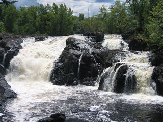
The Sioux-Hustler Trail heads north from the Echo Trail into the Boundary Waters. A spur forms the stick of a lollipop-shaped loop; follow it north to the Devil's Cascade at the north end of Lower Pauness Lake. A side trail off the 150-rod portage between Lower Pauness Lake and the river leads to a clearing that looks down into the cascade.
Plan your visit
Sioux-Hustler Trail north from the Echo Trail to the Devil's Cascade on the Little Indian Sioux River
Timberjay reports reaching the cascade at mile seven on a day hike, 14 miles there and back. This is a firsthand measurement, not an official trail length.
Wilderness trail with rocky and rooty sections, overlooks and shaded riverside stretches. The portage climbs a steep hill from the river side.
Where to start
The Timberjay article does not name the trailhead lot. BWCA Wild describes the nearby Entry Point 14 (Little Indian Sioux River North) lot on the Echo Trail with a restroom and day permit box; the exact Sioux-Hustler hiking trailhead parking was not confirmed.
Timing & water
Snow-free season. Water level changes the cascade greatly. Check Superior National Forest for any fire or trail closures.
Before you go
Inside the Boundary Waters Canoe Area Wilderness. BWCA Wild notes day permits in a box at the entry point bulletin board. Confirm current day-use permit rules with Superior National Forest.
Visitor informationVisit sources
More waterfalls nearby
Within 40 straight-line miles. Road and trail distances will differ.
- Loon FallsSt. Louis County, MN4.1 miNW
- Sioux FallsCanoe route documented; restricted BWCA permit quotaSt. Louis County, MN7.1 miS
- High FallsOfficial short trail and rest area documentedSt. Louis County, MN15 miW
- Dry FallsForest Service trail and published out-and-back distanceSt. Louis County, MN25 miSE
- Lower Basswood FallsLake County, MN26 miE
- Pipestone FallsCanoe route documented; parking and permit details unverifiedLake County, MN28 miSE
- Newton FallsLake County, MN29 miSE
 Kawishiwi FallsShort trail from a free lot; rocks and rootsLake County, MN29 miSE