Spoon Creek Falls
Grays Harbor County, Washington
Your visit at a glance
- Waterfall height
- Not recorded
- Location
- Grays Harbor County, Washington
- The walk
- 0.3-mile trail; return distance not explicitly stated
- Ground & access
- Steep descent through old-growth and second-growth conifer forest.
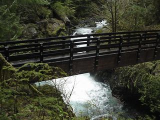
Descend Trail #885 to the creek near the base of Spoon Creek Falls.
Plan your visit
Spoon Creek Falls Trail #885
USFS describes a 0.3-mile trail descending to the creek, without separately labeling one-way or return mileage.
Steep descent through old-growth and second-growth conifer forest.
Where to start
Small roadside parking area on FS Road 23, reached via Wynoochee Valley Road/FS 22.
Timing & water
Trailhead listed open when checked 2026-10-27; page lists mid-spring as season of use. Current weather and road conditions are unknown.
Before you go
No fees required at the trailhead.
Visitor informationVisit sources
More waterfalls nearby
Within 40 straight-line miles. Road and trail distances will differ.
 Maidenhair FallsResearched walking routeGrays Harbor County, WA6.8 miN
- Wynoochee FallsRoute and parking documented by Washington Trails Association.Grays Harbor County, WA8.4 miN
- Merriman FallsRoadside waterfall on South Shore Road40 ft (12.2 m) · Grays Harbor County, WA14 miNW
- Cascade FallsShort national forest loop from the Quinault Ranger StationGrays Harbor County, WA15 miNW
- Ross FallsMason County, WA17 miNE
- Hamma Hamma FallsSource-reviewed route and parkingMason County, WA21 miNE
- Whitehorse FallsMason County, WA22 miNE
- Upper Lilliwaup FallsMason County, WA22 miE
- Lilliwaup FallsMason County, WA22 miE