Porter Falls
Grays Harbor County, Washington
Your visit at a glance
- Waterfall height
- Not recorded
- Location
- Grays Harbor County, Washington
- Access status
- State forest trail to the falls
- The walk
- 2.2 miles round trip (WTA); another guide gives 1.6 miles round trip
- Ground & access
- Forest trail with switchbacks and a traverse of a steep slope.
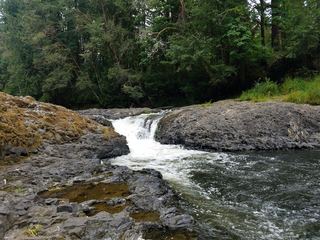
Porter Falls is at the meeting of the West Fork and South Fork of Porter Creek in Capitol State Forest, managed by the Washington State Department of Natural Resources. One branch cuts through a cleft while the other plunges over a ledge into a punchbowl. From the trailhead, the trail climbs several switchbacks and levels out partway up the hillside, then drops back to the creek and rises again to the West Fork of Porter Creek. Follow the West Fork down to the confluence and the falls. Return the same way.
Plan your visit
Porter Falls trailhead across the road from Porter Creek Campground in Capitol State Forest, up switchbacks and back down to the West Fork of Porter Creek and the falls
WTA gives 2.2 miles round trip with 450 feet of gain. The Waterfall Trail guide gives 1.6 miles round trip. The two sources do not agree.
Forest trail with switchbacks and a traverse of a steep slope.
Where to start
Trailhead on the left side of the B-Line road, just past the Porter Creek Campground entrance, about 4.5 miles from Highway 12 by Porter Creek Road in Porter.
Timing & water
Not stated.
Before you go
A Discover Pass is required.
Visitor informationVisit sources
More waterfalls nearby
Within 40 straight-line miles. Road and trail distances will differ.
- Kennedy FallsPrivate land open for walking; long logging road walk and an unmaintained footpathThurston County, WA9.6 miNE
- Mima FallsState forest trail loop from a signed trailhead; Discover PassThurston County, WA9.6 miSE
- She's a Butte FallsGrays Harbor County, WA15 miW
 Rainbow FallsState park riverbank beside the falls; exact viewing spot not described; Discover Pass requiredLewis County, WA24 miS
- Bloody FallsThurston County, WA29 miSE
- Spoon Creek FallsResearched visit notesGrays Harbor County, WA29 miNW
- Nisqually FallsPierce County, WA31 miE
- Lilliwaup FallsMason County, WA35 miN
- Upper Lilliwaup FallsMason County, WA35 miN