Mima Falls
Thurston County, Washington
Your visit at a glance
- Waterfall height
- Not recorded
- Location
- Thurston County, Washington
- Access status
- State forest trail loop from a signed trailhead; Discover Pass
- The walk
- 5.5-mile loop, per WTA
- Ground & access
- Forest trails with gentle ups and downs, road crossings, and many unsigned or similar-looking junctions shared with horse riders.
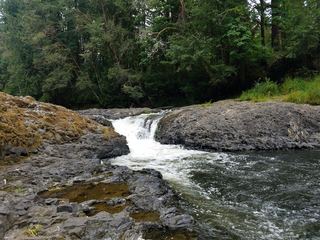
Mima Falls is in Capitol State Forest southwest of Olympia, a working forest managed by the Washington State Department of Natural Resources. From the Mima Falls trailhead, pass the kiosk and horse mounting ramp, walk through a young planting, cross the E-9000 road, and continue through older forest and past wetlands to the junction of the Mima Falls West and Mima Falls Tie trails. Take the Mima Falls West trail half a mile to the falls, where there is a picnic table. A small bridge crosses above the falls, and a side trail leads to a viewpoint at the bottom. Return to the junction and take the Mima Falls Tie trail, cross the E-9000 road again, then follow the Campground trail and the Mima Falls East trail back to the trailhead. Many horse trails, roads and hiking trails meet here; WTA advises carrying a map.
Plan your visit
Mima Falls Trailhead in Capitol State Forest, loop via the Mima Falls West trail to the falls and back by the Mima Falls Tie, Campground and Mima Falls East trails
WTA lists the Mima Falls Loop as 5.5 miles round trip. It places the falls half a mile along the Mima Falls West trail from its junction with the Mima Falls Tie trail.
Forest trails with gentle ups and downs, road crossings, and many unsigned or similar-looking junctions shared with horse riders.
Where to start
Mima Falls Trailhead lot, which holds about 30 cars, at the end of a gravel loop off Marksman Street SW. From I-5 exit 95, follow Maytown Road SW and 128th Ave to Mima Road SW, turn left, then right on Bordeaux Road SW and right on Marksman Street SW.
Timing & water
WTA calls it a year-round hike. Trails in this working forest can be closed temporarily for logging.
Before you go
Discover Pass, per WTA.
Visitor informationVisit sources
- Washington Trails Association: Capitol State Forest - Mima Falls Loop
- Washington Trails Association: Capitol State Forest - Mima Falls Loop
- Washington Trails Association: Capitol State Forest - Mima Falls Loop
- Washington Trails Association: Capitol State Forest - Mima Falls Loop
- Washington Trails Association: Capitol State Forest - Mima Falls Loop
- Washington Trails Association: Capitol State Forest - Mima Falls Loop
More waterfalls nearby
Within 40 straight-line miles. Road and trail distances will differ.
- Porter FallsState forest trail to the fallsGrays Harbor County, WA9.6 miNW
- Kennedy FallsPrivate land open for walking; long logging road walk and an unmaintained footpathThurston County, WA12 miN
- Bloody FallsThurston County, WA19 miSE
 Rainbow FallsState park riverbank beside the falls; exact viewing spot not described; Discover Pass requiredLewis County, WA21 miS
- Nisqually FallsPierce County, WA23 miE
- She's a Butte FallsGrays Harbor County, WA24 miW
- Deschutes FallsCounty park path to a railed viewing deckThurston County, WA33 miE
- Stillwater FallsCowlitz County, WA37 miS
- Spoon Creek FallsResearched visit notesGrays Harbor County, WA38 miNW