White Pine Cascades 28
Rhea County, Tennessee
Your visit at a glance
- Waterfall height
- Not recorded
- Location
- Rhea County, Tennessee
- Access status
- Guide: long Cumberland Trail hike from Shut-In Gap Road
- The walk
- 5.9 miles one way from the Piney River Trailhead
- Ground & access
- Long trail with a boulder crossing of McDonald Branch (no bridge), steep drop-offs in places, and stone slabs that are slick when wet or icy. Old mine openings above the trail are unstable; do not enter them.
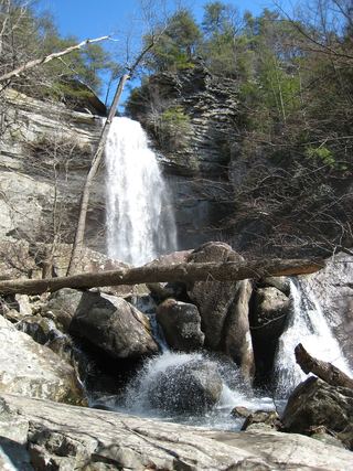
White Pine Cascades is a signed cascade on Duskin Creek on the Lower Piney section of the Cumberland Trail, historically called the Piney River Trail, near Spring City. Start at the Piney River Trailhead kiosk across Shut-In Gap Road from the Piney River Picnic Area. The trail follows the Piney River, crosses McDonald Branch on boulders, crosses the river on a 100-foot suspension bridge at mile 3.0, then follows Duskin Creek to White Pine Cascades at mile 5.9, marked by a wooden sign. The former Newby Branch and Duskin Creek trailheads are closed because the roads are private and the landowner does not allow parking or walking there; start and end at Shut-In Gap Road. Return the same way.
Plan your visit
Piney River Trailhead on Shut-In Gap Road, Cumberland Trail Lower Piney (Piney River) section south past the Piney River suspension bridge and up Duskin Creek to White Pine Cascades
The Cumberland Trail Conservancy mileage puts White Pine Cascades at mile 5.9 from the Piney River Trailhead at Shut-In Gap Road.
Long trail with a boulder crossing of McDonald Branch (no bridge), steep drop-offs in places, and stone slabs that are slick when wet or icy. Old mine openings above the trail are unstable; do not enter them.
Where to start
Piney River Picnic Area on Shut-In Gap Road, which has ample parking: from US 27 at Spring City, take TN 68 northeast 1.2 miles, turn left on Shut-In Gap Road, and go 1.1 miles. The trailhead is across the road from the picnic area.
Timing & water
Flow is strongest in the spring rainy season and may drop to a trickle in summer. The Piney River is prone to flash floods in heavy rain.
Before you go
No fee is mentioned. Overnight campers must register with Cumberland Trail State Park.
Visitor informationVisit sources
More waterfalls nearby
Within 40 straight-line miles. Road and trail distances will differ.
- Deep Pool Cascades 8Rhea County, TN0.8 miNE
- Hemlock FallsRhea County, TN0.9 miE
- Pine Branch FallsRhea County, TN1.6 miNE
- Stinging Fork Falls 60State natural area trail and parking documentedRhea County, TN2.4 miN
- Lower Piney Falls 40Rhea County, TN4.8 miNE
- Keaton FallsBledsoe County, TN5.0 miNW
- Upper Piney Falls 80Guide: state natural area trail to the falls and ledgeRhea County, TN5.0 miNE
- Ray FallsRhea County, TN8.3 miNE
 Laurel Falls 80State natural area trail route documentedRhea County, TN11 miSW