Stinging Fork Falls 60
Rhea County, Tennessee
Your visit at a glance
- Waterfall height
- Not recorded
- Location
- Rhea County, Tennessee
- Access status
- State natural area trail and parking documented
- The walk
- About 1 mile from the parking area to the bottom of the falls, per Tennessee Natural Areas
- Ground & access
- Natural-surface trail with stone steps and wooden stairs near the gorge. Rocky sections are slippery when wet.
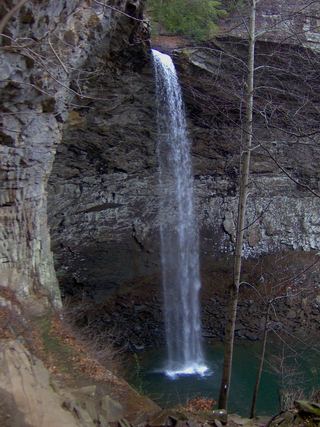
Stinging Fork Falls is a 30-foot, fan-shaped waterfall in the Stinging Fork gorge in Stinging Fork Falls State Natural Area, west of Spring City. From the parking area, the trail crosses upland pine forest toward the gorge, meets the Cumberland Trail, and ends at the bottom of the falls. A side trail leads to Indian Head Point, which looks down on the gorge 160 feet below. Return the same way.
Plan your visit
Stinging Fork Falls State Natural Area parking on Shut In Gap Road, connector trail and Stinging Fork Falls Trail to the bottom of the falls
Tennessee Natural Areas says the Stinging Fork Falls trail ends at the bottom of the falls about 1 mile from the parking area.
Natural-surface trail with stone steps and wooden stairs near the gorge. Rocky sections are slippery when wet.
Where to start
Trailhead parking on the right of Shut In Gap Road, about five miles from TN 68 in Spring City.
Timing & water
Public access is from sunrise to sunset. No camping in the natural area.
Before you go
No fee is mentioned.
Visitor informationVisit sources
- Tennessee Natural Areas: Stinging Fork Falls State Natural Area
- Tennessee Natural Areas: Stinging Fork Falls State Natural Area
- Tennessee Natural Areas: Stinging Fork Falls State Natural Area
- Tennessee Natural Areas: Stinging Fork Falls State Natural Area
- Cumberland Trail Conservancy: Stinging Fork section
More waterfalls nearby
Within 40 straight-line miles. Road and trail distances will differ.
- Pine Branch FallsRhea County, TN1.7 miSE
- Deep Pool Cascades 8Rhea County, TN2.0 miS
- Hemlock FallsRhea County, TN2.1 miS
- White Pine Cascades 28Guide: long Cumberland Trail hike from Shut-In Gap RoadRhea County, TN2.4 miS
- Keaton FallsBledsoe County, TN3.3 miNW
- Lower Piney Falls 40Rhea County, TN3.5 miE
- Upper Piney Falls 80Guide: state natural area trail to the falls and ledgeRhea County, TN3.6 miE
- Ray FallsRhea County, TN6.3 miNE
 Ozone FallsResearched walking route112 ft (34 m) · Cumberland County, TN13 miNE