Greeter Falls
Grundy County, Tennessee
Your visit at a glance
- Waterfall height
- Not recorded
- Location
- Grundy County, Tennessee
- Access status
- State park trail route and trailhead documented; steep stairs
- The walk
- Greeter Falls Day Loop about 1.4 miles in all (Friends of South Cumberland)
- Ground & access
- The loop descends about 240 feet. Steep sections near Greeter Falls use a metal spiral staircase, stairs and a wooden ramp that can be very slippery. Friends of South Cumberland rates it moderate to strenuous and mentions a rock scramble along a high narrow ledge under the bluff.
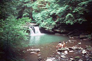
Greeter Falls is a free-falling waterfall of about 50 feet on Firescald Creek in Savage Gulf State Park. From the Greeter Falls parking area, the trail starts as a wide, nearly flat old road to a loop junction. The loop passes Boardtree Falls and Upper Greeter Falls, a 15-foot drop. Lower Greeter Falls, the main falls, is reached by a descending trail, a metal spiral staircase and wooden stairs and steps into a walled canyon. Return to the parking area on the loop.
Plan your visit
Savage Gulf West (Greeter Falls) trailhead, Greeter Falls loop trail, then a spiral staircase and wooden stairs down to Lower Greeter Falls
Friends of South Cumberland gives 1.4 miles for the Greeter Falls Day Loop, including the spur to the Greeter Home Place; the loop itself is 0.8 mile. Tennessee State Parks lists the Greeter Falls Trail at 0.50 mile without saying whether that is one way.
The loop descends about 240 feet. Steep sections near Greeter Falls use a metal spiral staircase, stairs and a wooden ramp that can be very slippery. Friends of South Cumberland rates it moderate to strenuous and mentions a rock scramble along a high narrow ledge under the bluff.
Where to start
Savage Gulf State Park West trailhead, 550 Greeter Falls Rd, Altamont, with 45 parking spaces and no amenities. From Hwy 56, turn east at the brown Greeter Falls sign and drive 0.4 mile to the lot on the north side of the road.
Timing & water
No seasonal closure is mentioned. Stairs and rocks near the falls are slippery when wet.
Before you go
No fee is mentioned.
Visitor informationVisit sources
More waterfalls nearby
Within 40 straight-line miles. Road and trail distances will differ.
- Ranger FallsPartial guide: trails and trailhead named; turn-by-turn route and distance to the falls not givenGrundy County, TN2.2 miE
- Horsepound FallsGuide: difficult river-gorge trail past Suter FallsGrundy County, TN5.3 miE
- Suter FallsGuide: difficult trail into the Collins River gorgeGrundy County, TN5.8 miE
- Savage FallsState park trail route and trailhead documentedGrundy County, TN8.0 miE
- Small WaterfallGrundy County, TN13 miS
 Blue Hole FallsState park trail route and trailhead documentedGrundy County, TN13 miS
- Hanes Hole FallsState park loop trail and trailhead documentedGrundy County, TN13 miS
- Black Canyon FallsState natural area trail passes the fallsGrundy County, TN13 miS
- Sycamore FallsState park trail route and trailhead documentedGrundy County, TN13 miS