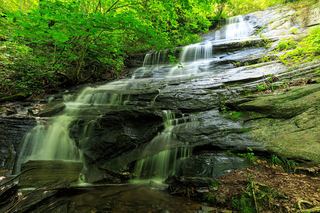
Poundingmill Branch Falls
Transylvania County, North Carolina
Your visit at a glance
- Waterfall height
- Not recorded
- Location
- Transylvania County, North Carolina
- Access status
- Forest road and unofficial path in Pisgah National Forest
- The walk
- About 1.8 miles return
- Ground & access
- Grassy forest road, then an unofficial path. NCWaterfalls calls it a moderate Class I bushwhack; the legacy account describes the last quarter mile as off trail with fallen trees to climb over.
Start on FS 5032 across the road from the parking area. Just before the gate (about 80 yards), take the side path on the right and climb a little over a quarter mile to rejoin FS 5032 at a wildlife clearing. Turn right and follow the road about 0.4 miles to its end at another clearing. Walk through the clearing and follow the path about 0.2 miles to the falls.
Plan your visit
FS 475B (Headwaters Road) parking off US 276 via FS 5032 and a short path to Poundingmill Branch Falls
NCWaterfalls gives a hike distance of 0.9 miles for the short route; its segments (80 yards, a little over 0.25 miles, about 0.4 miles, about 0.2 miles) add to that one way. Same route both ways.
Grassy forest road, then an unofficial path. NCWaterfalls calls it a moderate Class I bushwhack; the legacy account describes the last quarter mile as off trail with fallen trees to climb over.
Where to start
From the US 64/US 276/NC 280 junction in Brevard, drive north on US 276 about 10.1 to 10.3 miles (4.7 miles south of the Blue Ridge Parkway) and turn left on unpaved FS 475B. Park on the left about 0.1 to 0.15 miles in, just before the bridge.
Timing & water
Low flow in dry periods. Pisgah National Forest had widespread Hurricane Helene damage; FS 475B and FS 5032 are not on the Forest Service closure list, but current conditions were not confirmed.
Before you go
Current fees and reservation requirements unknown.
Visitor informationVisit sources
More waterfalls nearby
Within 40 straight-line miles. Road and trail distances will differ.
- No-Name Cove FallsSide path and faint path; scramble to the upper baseTransylvania County, NC0.4 miSW
- Pigeon Branch FallsPartial guide: off-trail route; the waterfall position is not publishedTransylvania County, NC0.9 miN
- Bennett Cove FallsPublished route on national forest land; informal side pathsTransylvania County, NC1.2 miSW
- Cherry Cove FallsDetailed firsthand route on unofficial paths from a Forest Service roadTransylvania County, NC1.4 miSW
- Powerline FallsTransylvania County, NC1.7 miSE
- Justus Cove FallsTransylvania County, NC1.7 miS
- Bullpen Cove FallsHaywood County, NC1.8 miNW
 Barnett Branch Trail FallsShort national forest trail walk to fallsTransylvania County, NC1.8 miNE
- Cradle FallsTransylvania County, NC1.9 miN