Lower Falls
Franklin County, New York
Your visit at a glance
- Waterfall height
- Not recorded
- Location
- Franklin County, New York
- Access status
- Wilderness trail and trailhead documented
- The walk
- About 4.2 miles one way
- Ground & access
- Long, mostly gentle forest trail; wet sections and short flooded stretches in early season. Biting insects can be intense.
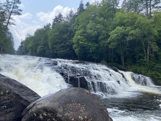
Take Coreys Road south from NY 3 between Tupper Lake and Saranac Lake for about 3 miles and park in the lot on the right about 0.2 miles past Stoney Creek. The trail starts at the rear right of the lot behind the register kiosk and is well signed. Just beyond four miles you reach a clearing with a barn-type building and a ranger residence; continue to a sign for Lower Falls and go to the river. The Lower Falls is a low slide, more like rapids, at an S-bend in the Raquette River. Return the same way.
Plan your visit
Raquette Falls trailhead on Coreys Road off NY 3, Raquette Falls Trail about 4 miles to the ranger station clearing, then the signed spur to Lower Falls
Northern New York Waterfalls lists the hike as 4.2 miles one way. Protect the Adirondacks gives 4.4 miles one way to Raquette Falls, the farther falls on the same trail.
Long, mostly gentle forest trail; wet sections and short flooded stretches in early season. Biting insects can be intense.
Where to start
Unpaved trailhead lot on the right side of Coreys Road, about 0.2 miles after crossing Stoney Creek.
Timing & water
Wet trail in spring. Protect the Adirondacks lists the trail for hiking, snowshoeing and cross-country skiing.
Before you go
High Peaks Wilderness (NYS DEC). No fee is stated by the sources.
Visitor informationVisit sources
More waterfalls nearby
Within 40 straight-line miles. Road and trail distances will differ.
- Raquette FallsWilderness trail and trailhead documentedFranklin County, NY0.1 miSW
- Upper FallsLong public trail along the Raquette RiverFranklin County, NY0.5 miSW
- Millers FallsRemote wilderness trail; overnight trip on the Northville-Placid TrailEssex County, NY6.3 miSE
- Wanika FallsLong public trail; stream ford at the fallsEssex County, NY14 miE
- Rocky FallsMarked trail from the Adirondak Loj lot; parking feeEssex County, NY16 miE
- Hanging Spear FallsLong wilderness hike; view the falls from the trailEssex County, NY17 miE
- MacIntyre FallsHigh Peaks trail route from the Adirondak Loj; about 2.5 miles one wayEssex County, NY17 miE
 Buttermilk FallsShort trail and signed parking documentedHamilton County, NY18 miSW
- Indian FallsWilderness trail; long day hike from a fee trailheadEssex County, NY19 miE