Waterfalls near Fort Smith, AR
8 named waterfalls within 30 miles of Fort Smith, closest first. Distances are straight-line from the town center.
Visits with route details
Read the walking route, starting point and current access notes.
- McWater FallsResearched walking routeCrawford County, AR
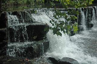 Natural Dam WaterfallRoadside view and adjacent parking documented8 ft (2.4 m) · Crawford County, AR
- Devil's Canyon FallsPartial guide: private-gate permission and current parking access unverified63 ft (19.2 m) · Franklin County, AR
- Devil's Canyon Jr FallsPartial: parking authorization and current route condition unresolved18 ft (5.5 m) · Franklin County, AR
- Artist Point FallsClosure reported; reopening unverified15 ft (4.6 m) · Crawford County, AR
- Slate FallsPartial: off-trail route from older sources; exact parking and road condition unconfirmed54 ft (16.5 m) · Sebastian County, AR
- Twin FallsOfficial trail and firsthand visitor-center parking approach documentedWashington County, AR
All 8 waterfalls
- McWater FallsResearched walking routeCrawford County, AR13 miNE
- Natural Dam WaterfallRoadside view and adjacent parking documented8 ft (2.4 m) · Crawford County, AR18 miN
- Devil's Canyon FallsPartial guide: private-gate permission and current parking access unverified63 ft (19.2 m) · Franklin County, AR27 miNE
- Devil's Canyon Jr FallsPartial: parking authorization and current route condition unresolved18 ft (5.5 m) · Franklin County, AR27 miNE
- Artist Point FallsClosure reported; reopening unverified15 ft (4.6 m) · Crawford County, AR28 miNE
- Slate FallsPartial: off-trail route from older sources; exact parking and road condition unconfirmed54 ft (16.5 m) · Sebastian County, AR29 miS
- Twin FallsOfficial trail and firsthand visitor-center parking approach documentedWashington County, AR29 miN
- Belle Star Cave Falls27 ft (8.2 m) · Sebastian County, AR29 miS