Twin Falls
Washington County, Arkansas
Your visit at a glance
- Waterfall height
- Not recorded
- Location
- Washington County, Arkansas
- Access status
- Official trail and firsthand visitor-center parking approach documented
- The walk
- Official trail length 1.5 miles; firsthand loop measured about 1.2 miles
- Ground & access
- Rocky trail, stone steps, crevices and exposed drop-offs. The park rates the trail moderate. Remain on the marked trail.
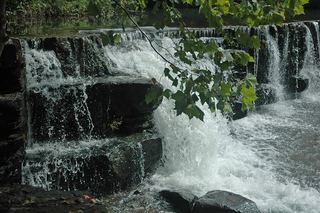
Start behind the visitor center. The firsthand account descends stone steps, keeps right at the north-trailhead junction and again at the main loop. Follow the red-blazed loop past the rock formations to Twin Falls. After the falls, follow the switchbacks and keep left at the lower junction to rejoin the initial spur.
Plan your visit
Devil’s Den National Recreation Trail loop past Twin Falls
The current park page lists 1.5 miles for the trail without a separate waterfall-only distance. Mike Newman’s visitor-center loop is about 1.2 miles total, with Twin Falls around 0.65 mile along that itinerary.
Rocky trail, stone steps, crevices and exposed drop-offs. The park rates the trail moderate. Remain on the marked trail.
Where to start
Mike Newman documents parking at the west trailhead behind the visitor center. The park is at 11333 West Arkansas Highway 74, West Fork. A second trailhead exists by Lee Creek bridge, but its distances are not used here.
Timing & water
Wet-weather waterfalls may be dry. The current official trail page does not post a closure; no current cave-entry permission is established by this walking guide.
Before you go
Current day-use fee and reservation requirements not stated on the reviewed trail page.
Visitor informationVisit sources
More waterfalls nearby
Within 40 straight-line miles. Road and trail distances will differ.
- Artist Point FallsClosure reported; reopening unverified15 ft (4.6 m) · Crawford County, AR7.5 miSE
 Natural Dam WaterfallRoadside view and adjacent parking documented8 ft (2.4 m) · Crawford County, AR13 miSW
- Dockery Gap FallsResearched visit notes36 ft (11 m) · Crawford County, AR13 miE
- Devil's Canyon FallsPartial guide: private-gate permission and current parking access unverified63 ft (19.2 m) · Franklin County, AR15 miSE
- Devil's Canyon Jr FallsPartial: parking authorization and current route condition unresolved18 ft (5.5 m) · Franklin County, AR16 miSE
- White Rock Creek Falls31 ft (9.5 m) · Franklin County, AR17 miSE
- White Rock Creek CascadePartial guide: historical roadside start lacks verified safe parking10 ft (3 m) · Franklin County, AR17 miSE
- Jack White FallsHistorical route; current parking access unverified41 ft (12.5 m) · Franklin County, AR17 miE
- McWater FallsResearched walking routeCrawford County, AR19 miS