Monkeyface Falls
San Bernardino County, California
Your visit at a glance
- Waterfall height
- Not recorded
- Location
- San Bernardino County, California
- Access status
- Partial: climbing-area approach; exact falls and parking rules not confirmed
- The walk
- About 15 minutes to the canyon base; distance not published
- Ground & access
- Talus field on the approach, then boulders and scrambling. Deeper sections need class 4 scrambling and some climbers rappel. This is an active rock-climbing area.
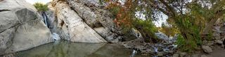
Mountain Project describes Monkeyface Falls as a slot canyon climbing area with waterfalls, off Highway 38 above Mentone. Just before the sharp bend in Highway 38, continue straight onto Valley of the Falls Drive. About a quarter mile on, park at a dirt pull-off on the right. Walk back a little, cross the road to the approach trail, and cross a talus field to the base of the canyon. The source does not say which waterfall in the canyon carries the Monkeyface Falls name. Deeper parts of the canyon need class 4 scrambling.
Plan your visit
Valley of the Falls Drive pullout to the Monkeyface Falls canyon (climbing area approach)
Mountain Project gives time only: a 5-minute walk to a talus field and about 15 minutes to the base of the canyon. No distance was published and none was measured.
Talus field on the approach, then boulders and scrambling. Deeper sections need class 4 scrambling and some climbers rappel. This is an active rock-climbing area.
Where to start
Dirt pull-off on the right side of Valley of the Falls Drive about a quarter mile past Highway 38, per Mountain Project. The land manager and any parking rules were not confirmed.
Timing & water
Current flow and access not verified. The waterfall named on the map may run only after rain or snowmelt.
Before you go
No fee or permit information was found in the reviewed sources.
Visitor informationVisit sources
More waterfalls nearby
Within 40 straight-line miles. Road and trail distances will differ.
- Monkeyface CreekSan Bernardino County, CA0.0 miSW
- Big FallsUpper falls area closed; overlook route onlySan Bernardino County, CA3.5 miE
- Silverwood FallsSan Bernardino County, CA8.1 miE
- Aztec FallsClosed by Forest Order through June 7, 2027San Bernardino County, CA16 miNW
- Hesperia FallsSan Bernardino County, CA22 miNW
- Fuller Mill Creek FallsRiverside County, CA24 miSE
- Middleman FallsSan Bernardino County, CA29 miW
- Dry FallsRiverside County, CA29 miSE
 Tahquitz FallsOfficial trail, hours and admission documentedRiverside County, CA30 miSE