Big Falls
San Bernardino County, California
Your visit at a glance
- Waterfall height
- Not recorded
- Location
- San Bernardino County, California
- Access status
- Upper falls area closed; overlook route only
- The walk
- Page lists 0.29 mile without stating one-way or round-trip. Full walk time unknown.
- Ground & access
- Easy-rated trail with a wash crossing; avoid crossing in high flow or forecast thunderstorms.
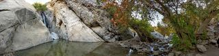
Walk downstream, cross the wash, then follow the trail uphill to the overlook. Do not continue into the closed upper-falls area.
Plan your visit
Big Falls Trail 1E13 to the overlook
Page lists 0.29 mile without stating one-way or round-trip. Full walk time unknown.
Easy-rated trail with a wash crossing; avoid crossing in high flow or forecast thunderstorms.
Where to start
First main lot on the left at the upper end of Valley of the Falls Road, immediately before the picnic area.
Timing & water
Upper area closed July 13, 2026–July 13, 2028; stop at the official overlook.
Before you go
Recreation passes honored; current price not stated.
Visitor informationVisit sources
More waterfalls nearby
Within 40 straight-line miles. Road and trail distances will differ.
- Monkeyface FallsPartial: climbing-area approach; exact falls and parking rules not confirmedSan Bernardino County, CA3.5 miW
- Monkeyface CreekSan Bernardino County, CA3.6 miW
- Silverwood FallsSan Bernardino County, CA4.5 miE
- Aztec FallsClosed by Forest Order through June 7, 2027San Bernardino County, CA19 miNW
- Fuller Mill Creek FallsRiverside County, CA21 miSE
- Hesperia FallsSan Bernardino County, CA25 miNW
- Dry FallsRiverside County, CA26 miSE
 Tahquitz FallsOfficial trail, hours and admission documentedRiverside County, CA27 miSE
- Andreas FallsRiverside County, CA28 miSE