Stafford Falls
Pierce County, Washington
Your visit at a glance
- Waterfall height
- Not recorded
- Location
- Pierce County, Washington
- Access status
- National park trail from a roadside trailhead; steep climb on the return
- The walk
- 4 miles round trip, per WTA
- Ground & access
- Drops almost 300 feet in the first 0.4 mile, so the return ends with a climb. The viewpoint has vertical rock walls; use caution.
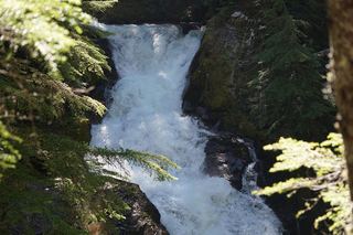
Stafford Falls drops about 25 to 30 feet into a basalt punch bowl on Chinook Creek in Mount Rainier National Park. From the road-shoulder parking on State Route 123, cross the road to the Owyhigh Lakes trailhead sign. The trail drops almost 300 feet in 0.4 mile beside Deer Creek to the Eastside Trail. Turn south (right first if you want a short look at Chinook Creek from a second bridge), pass Deer Creek Camp, and follow Chinook Creek downstream past pools and a bridge over a rocky chute. About 1.5 miles from the junction, a short side trail leads to a viewpoint level with the top of the falls. Return the same way. This is not the Owyhigh Lakes trailhead near the White River entrance.
Plan your visit
Owyhigh Lakes trailhead on State Route 123 (Deer Creek), down the Owyhigh Lakes Trail to the Eastside Trail, then south along Chinook Creek to the Stafford Falls spur
WTA gives 4 miles round trip. The National Park Service gives 0.4 mile on the Owyhigh Lakes Trail to the Eastside Trail, then about 1.4 miles south to the viewpoint spur; WTA puts the spur at 1.5 miles from the junction.
Drops almost 300 feet in the first 0.4 mile, so the return ends with a climb. The viewpoint has vertical rock walls; use caution.
Where to start
Road-shoulder parking on State Route 123 across from the Owyhigh Lakes trailhead sign (the Deer Creek end of the Owyhigh Lakes Trail).
Timing & water
No season limits are stated.
Before you go
WTA says no pass or entry fee is required for this hike; national park rules apply.
Visitor informationVisit sources
- Washington Trails Association: Stafford Falls via Deer Creek
- Washington Trails Association: Stafford Falls via Deer Creek
- Washington Trails Association: Stafford Falls via Deer Creek
- Washington Trails Association: Stafford Falls via Deer Creek
- Washington Trails Association: Stafford Falls via Deer Creek
- National Park Service: Mount Rainier waterfall guide
More waterfalls nearby
Within 40 straight-line miles. Road and trail distances will differ.
- Chinook CascadesPierce County, WA0.5 miNE
 Deer Creek FallsShort official park trail from SR 123; road closed in winterPierce County, WA1.2 miNE
- Sydney Falls192 ft (58.5 m) · Pierce County, WA1.4 miN
- Marie FallsPierce County, WA3.6 miW
- Mary Belle FallsPierce County, WA3.8 miW
- Wauhaukaupauken FallsLong national park trail to a bridge across the fallsPierce County, WA4.1 miW
- Twin FallsPierce County, WA4.3 miW
- Trixie FallsPierce County, WA4.5 miW
- Basaltic FallsPierce County, WA4.6 miW