Comer’s Creek Falls
Grayson County, Virginia
Your visit at a glance
- Waterfall height
- Not recorded
- Location
- Grayson County, Virginia
- Access status
- Guide: short forest trail to a small falls
- The walk
- Falls trail about 1/4 mile to the Appalachian Trail, then a short distance; Waterfall Hero lists the hike as 0.6 miles
- Ground & access
- Short descending trail; rough scramble at the end. Rocks around the falls are very slippery.
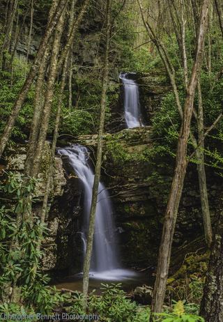
Comers Creek Falls is a small waterfall on Comers Creek in Mount Rogers National Recreation Area, Jefferson National Forest. From the pull-off on Homestead Road, take the blue-blazed Comers Creek Falls Trail (#4576) down along the creek. It ends in about a quarter mile at the Appalachian Trail. Turn right and go a short distance to where the Appalachian Trail crosses the creek. The footbridge there was washed out. Before the crossing you can scramble up to the base for a good view of the falls. Return the same way.
Plan your visit
Trailhead pull-off on Homestead Road (CR-641), blue-blazed Comers Creek Falls Trail down to the Appalachian Trail, then right to the creek crossing below the falls
Waterfall Hero says the Comers Creek Falls Trail ends in 1/4 mile at the Appalachian Trail and the falls are a short distance farther. It lists the hike length as 0.6 miles but does not say whether that is round trip.
Short descending trail; rough scramble at the end. Rocks around the falls are very slippery.
Where to start
Pull-off on the right of Homestead Road (CR-641), 0.5 mile along the gravel road from VA-16. Parking is very limited.
Timing & water
No season limits are stated.
Before you go
No fee is mentioned. No booking is needed.
Visitor informationVisit sources
More waterfalls nearby
Within 40 straight-line miles. Road and trail distances will differ.
- Straight Branch FallsPartial: roadside viewpoint described by a visitor source; parking area not confirmed by the land managerWashington County, VA14 miW
- Whitetop Laurel FallsWashington County, VA16 miW
 Gentry Creek FallsResearched walking routeJohnson County, TN16 miSW
- Sharpes FallsAshe County, NC18 miS
- Bluff Mountain FallsAshe County, NC22 miS
- Nana FallsPartial guide: roadside view; no parking spot describedAshe County, NC23 miS
- Incredible Falls98 ft (30 m) · Wilkes County, NC29 miSE
- Bullhead Creek CascadesWilkes County, NC30 miSE
- Betsy's Rock FallsParkway overlook view; falls on private propertyAshe County, NC30 miS