High Falls
St. Lawrence County, New York
Your visit at a glance
- Waterfall height
- Not recorded
- Location
- St. Lawrence County, New York
- Access status
- Remote wilderness hike; often an overnight trip
- The walk
- About 9 miles to the spur junction, then 0.4 miles to the falls
- Ground & access
- Long but mostly gentle trail with beaver dams and water crossings. Remote wilderness.
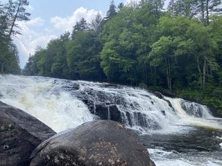
High Falls is a 15-foot drop, the largest on the main Oswegatchie River, deep in the Five Ponds Wilderness. Park at the Dead Creek Flow trailhead on South Shore Road in Wanakena and walk the road about half a mile to the High Falls trailhead. The trail follows an old railroad bed beside Skate Creek, with some beaver flooding. Pass the short spur to High Rock, continue straight at the Sand Lake junction at about 8 miles, and at about 9 miles turn right on the 0.4-mile spur to High Falls. Two lean-tos sit near the falls, one on each side of the river. Return the same way, or continue on the Cranberry Lake 50 trail to complete the loop back to Wanakena.
Plan your visit
Dead Creek Flow trailhead on South Shore Road in Wanakena, road walk to the High Falls trailhead, High Falls Loop Trail along Skate Creek to the junction at about 9 miles, then right on the 0.4-mile spur to High Falls
The Tupper Lake tourism office gives the spur junction at 9 miles in and the spur as 0.4 miles; its full loop with the side trip is 16.2 miles round trip.
Long but mostly gentle trail with beaver dams and water crossings. Remote wilderness.
Where to start
Dead Creek Flow trailhead parking on the right on South Shore Road, about 0.25 miles in from Wanakena Road (County Route 61).
Timing & water
Usually done as an overnight trip. Beaver flooding and Skate Creek crossings can be hard after rain.
Before you go
No fee is listed.
Visitor informationVisit sources
More waterfalls nearby
Within 40 straight-line miles. Road and trail distances will differ.
- Copper Rock FallsState land; short trail from Tooley Pond RoadSt. Lawrence County, NY15 miN
- Rainbow FallsShort state land trail from Tooley Pond RoadSt. Lawrence County, NY17 miN
- Flat Rock FallsSt. Lawrence County, NY18 miN
- Twin FallsShort signed path on DEC state land from roadside parkingSt. Lawrence County, NY19 miN
- Sinclair FallsState land; short trail from Lake George Road near the Tooley Pond Road parking areaSt. Lawrence County, NY20 miN
- Basford FallsState land; short signed trail from Tooley Pond RoadSt. Lawrence County, NY20 miN
- Jamestown FallsView from a state land boat launchSt. Lawrence County, NY20 miNE
 Buttermilk FallsShort trail and signed parking documentedHamilton County, NY24 miSE
- Lampson FallsState forest trail and parking documented; accessible trail closure stated by DECSt. Lawrence County, NY25 miN