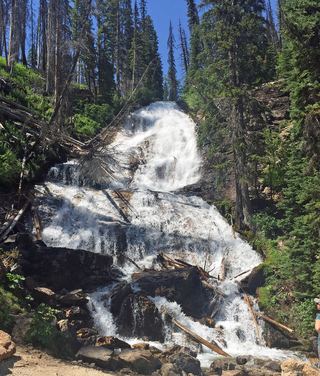
Canyon Falls
Ravalli County, Montana
Your visit at a glance
- Waterfall height
- Not recorded
- Location
- Ravalli County, Montana
- Access status
- Forest Service trail; distance to the falls not officially confirmed
- The walk
- About 3.8 miles one way (reported); Canyon Lake is 4.5 miles
- Ground & access
- Rugged, steep and switchbacking, with little shade in the final mile, per the Forest Service. About 1,950 feet of gain to the falls is reported.
From Hamilton, drive to the Canyon Creek Trailhead at the end of Canyon Creek Road. Hike Canyon Creek Trail #525 up the canyon. The trail enters the Selway-Bitterroot Wilderness about 1.5 miles in, then climbs steeply with many switchbacks toward Canyon Lake. Canyon Falls is reported about 3.8 miles up, below the lake. Return the same way.
Plan your visit
Canyon Creek Trailhead at the end of Canyon Creek Road on Canyon Creek Trail #525 toward Canyon Lake
The Forest Service gives 4.5 miles for the whole trail to Canyon Lake. Discovering Montana reports 3.8 miles from the trailhead to the falls; that figure is not confirmed by the Forest Service.
Rugged, steep and switchbacking, with little shade in the final mile, per the Forest Service. About 1,950 feet of gain to the falls is reported.
Where to start
Canyon Creek Trailhead at the end of Canyon Creek Road (FS road 735).
Timing & water
Snow and mud affect the road and upper trail; summer to early fall is usual. Not stated by the Forest Service.
Before you go
No fee is listed on the Forest Service trail page read. Wilderness rules apply: no bikes or motor vehicles.
Visitor informationMore waterfalls nearby
Within 40 straight-line miles. Road and trail distances will differ.
- Lower Sweathouse FallsRavalli County, MT13 miN
- Upper Sweathouse FallsRavalli County, MT13 miN
- Patsy Ann FallsIdaho County, ID21 miS
 Skalkaho FallsRoadside falls on a seasonal highway; parking not confirmedRavalli County, MT24 miE
- Boulder FallsOfficial trailhead and published trail distance documentedRavalli County, MT27 miS
- Overwich FallsRavalli County, MT38 miS