Boulder Falls
Ravalli County, Montana
Your visit at a glance
- Waterfall height
- Not recorded
- Location
- Ravalli County, Montana
- Access status
- Official trailhead and published trail distance documented
- The walk
- About 7 miles return
- Ground & access
- Gentle climb on forest trail; granite slabs at the falls can be slick.
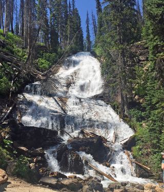
From the Boulder Creek Trailhead near Sam Billings Memorial Campground, follow the Boulder Creek Trail up the creek through forest below rock pinnacles to Boulder Falls, where the creek has cut a deep channel through granite slabs. The trail enters the Selway-Bitterroot Wilderness at about 2.5 miles.
Plan your visit
Boulder Creek Trailhead up Boulder Creek Trail 617 to Boulder Falls
Wild Montana lists 7 miles round trip and 800 feet of gain to the waterfall.
Gentle climb on forest trail; granite slabs at the falls can be slick.
Where to start
Boulder Creek Trailhead (45.829473, -114.252551): from Darby go south 4.3 miles on Highway 93, right on West Fork Road 13.2 miles, right on Sam Billings Road FS 5731 for 0.8 mile, then 0.4 mile on Boulder Creek Road. Large lot including trailer parking. USFS recommends high-clearance vehicles on forest roads.
Timing & water
Snow-free season. USFS says forest road conditions change; check road status.
Before you go
No fee or reservation found on the USFS trailhead page. Wilderness rules apply past about 2.5 miles.
Visitor informationVisit sources
More waterfalls nearby
Within 40 straight-line miles. Road and trail distances will differ.
- Patsy Ann FallsIdaho County, ID9.9 miNW
- Overwich FallsRavalli County, MT15 miSE
- Canyon FallsForest Service trail; distance to the falls not officially confirmedRavalli County, MT27 miN
- Star FallsRavalli County, MT34 miE
 Skalkaho FallsRoadside falls on a seasonal highway; parking not confirmedRavalli County, MT36 miNE
- Lower Sweathouse FallsRavalli County, MT39 miN
- Upper Sweathouse FallsRavalli County, MT39 miN